Poster Print > Maps and Charts > Willem Janszoon Blaeu
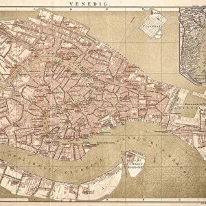
Poster Print : Atlas Novus. Europe, 17th c Venice


![]()
Poster Prints From Mary Evans Picture Library
Atlas Novus. Europe, 17th c Venice
BLAEU, Jan (1596-1673). Atlas Novus or Atlas Maior. 1635 - 1665. Europa recens descripta. Map of Europe printed in Amsterdam ca. 1633. Detail of the city of Venice. Etching. SPAIN. CATALONIA. Barcelona. Biblioteca de Catalunya (National Library of Catalonia)
Mary Evans Picture Library makes available wonderful images created for people to enjoy over the centuries
Media ID 14179320
© Iberfoto/Mary Evans
1571 1596 1633 1635 1638 1665 1673 Adriatic Amsterdam Atlas Barcelona Biblioteca Blaeu Canal Cartographic Cartographies Cartography Catalonia Catalunya Channel Cities Engravings Etching Etchings Europa Janszoon Maior Monde Novus Venice Willem Descripta
18x24 inch Poster Print
Introduce a touch of history and elegance to your space with our stunning Atlas Novus. Europe, 17th c Venice poster print from Media Storehouse. This exquisite etching, originally created by Jan Blaeu in Amsterdam around 1633, showcases a detailed and intricately designed map of Europe with a focus on the vibrant city of Venice. With its rich history and timeless appeal, this rights-managed print from Mary Evans Prints Online is a must-have for history enthusiasts, art collectors, or anyone looking to add a unique and captivating piece to their decor. Bring the old world charm into your modern home or office with this beautiful Atlas Novus poster print.
Poster prints are budget friendly enlarged prints in standard poster paper sizes. Printed on 150 gsm Matte Paper for a natural feel and supplied rolled in a tube. Great for framing and should last many years. To clean wipe with a microfiber, non-abrasive cloth or napkin. Our Archival Quality Photo Prints and Fine Art Paper Prints are printed on higher quality paper and the choice of which largely depends on your budget.
Poster prints are budget friendly enlarged prints in standard poster paper sizes (A0, A1, A2, A3 etc). Whilst poster paper is sometimes thinner and less durable than our other paper types, they are still ok for framing and should last many years. Our Archival Quality Photo Prints and Fine Art Paper Prints are printed on higher quality paper and the choice of which largely depends on your budget.
Estimated Product Size is 61.6cm x 46.3cm (24.3" x 18.2")
These are individually made so all sizes are approximate
Artwork printed orientated as per the preview above, with landscape (horizontal) orientation to match the source image.
FEATURES IN THESE COLLECTIONS
> Europe
> Spain
> Related Images
> Maps and Charts
> Willem Janszoon Blaeu
EDITORS COMMENTS
This detail is taken from the Atlas Novus, or Atlas Maior, a seminal work of cartography produced by the renowned Flemish cartographer Jan Blaeu and his team in Amsterdam around 1633. The map, titled Europa recens descripta, offers an intricately detailed representation of Europe during the 17th century. This particular section showcases the city of Venice, a cultural and commercial hub of the time. The etching, which is part of a larger atlas, displays the urban layout of the city, including its iconic Le Theatre du Monde, the Rialto Bridge, and the Grand Canal. Blaeu, who was born in the Netherlands but spent a significant portion of his life in Italy, drew upon the latest cartographic knowledge and techniques to create this masterpiece. The map was published during the height of the Dutch Golden Age, a period marked by significant advancements in cartography and exploration. The Atlas Novus was produced using the most advanced etching techniques of the time, resulting in a highly detailed and visually stunning representation of Europe. This map was part of a larger project, which included the publication of the Atlas Maior, an extensive atlas that covered the entire world. This section of the map, which is now housed in the Biblioteca de Catalunya (National Library of Catalonia) in Barcelona, Spain, offers a glimpse into the urban landscape of Venice during the 17th century. The map's intricate details, from the winding canals to the architectural features of the city, provide a fascinating window into the past and offer a reminder of the rich cartographic heritage of Europe.
MADE IN THE USA
Safe Shipping with 30 Day Money Back Guarantee
FREE PERSONALISATION*
We are proud to offer a range of customisation features including Personalised Captions, Color Filters and Picture Zoom Tools
SECURE PAYMENTS
We happily accept a wide range of payment options so you can pay for the things you need in the way that is most convenient for you
* Options may vary by product and licensing agreement. Zoomed Pictures can be adjusted in the Basket.