Metal Print > Maps and Charts > Willem Janszoon Blaeu
Metal Print : Atlas Novus. Europe, 17th c Venice


![]()
Metal Prints From Mary Evans Picture Library
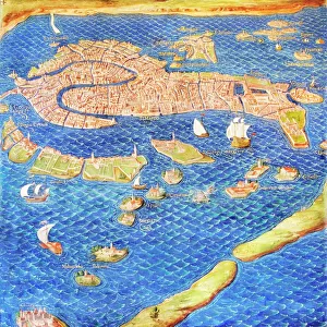
Atlas Novus. Europe, 17th c Venice
BLAEU, Jan (1596-1673). Atlas Novus or Atlas Maior. 1635 - 1665. Europa recens descripta. Map of Europe printed in Amsterdam ca. 1633. Detail of the city of Venice. Etching. SPAIN. CATALONIA. Barcelona. Biblioteca de Catalunya (National Library of Catalonia)
Mary Evans Picture Library makes available wonderful images created for people to enjoy over the centuries
Media ID 14179320
© Iberfoto/Mary Evans
1571 1596 1633 1635 1638 1665 1673 Adriatic Amsterdam Atlas Barcelona Biblioteca Blaeu Canal Cartographic Cartographies Cartography Catalonia Catalunya Channel Cities Engravings Etching Etchings Europa Janszoon Maior Monde Novus Venice Willem Descripta
16"x20" (51x41cm) Metal Print
Discover the captivating beauty of Europe's historic cities with our Media Storehouse Metal Prints. Featuring an intricately detailed etching of Venice from the Atlas Novus map by Jan Blaeu, this exquisite print showcases the grandeur of Europe in the 17th century. With Mary Evans Prints Online's Rights Managed image, you can bring the rich history of Venice right into your home or office. Our high-quality metal prints are not only visually stunning but also durable and long-lasting, making them a perfect addition to any space. Elevate your decor with this unique and captivating piece of historical art.
Made with durable metal and luxurious printing techniques, our metal photo prints go beyond traditional canvases, adding a cool, modern touch to your space. Wall mount on back. Eco-friendly 100% post-consumer recycled ChromaLuxe aluminum surface. The thickness of the print is 0.045". Featuring a Scratch-resistant surface and Rounded corners. Backing hangers are attached to the back of the print and float the print 1/2-inch off the wall when hung, the choice of hanger may vary depending on size and International orders will come with Float Mount hangers only. Finished with a brilliant white high gloss surface for unsurpassed detail and vibrance. Printed using Dye-Sublimation and for best care we recommend a non-ammonia glass cleaner, water, or isopropyl (rubbing) alcohol to prevent harming the print surface. We recommend using a clean, lint-free cloth to wipe off the print. The ultra-hard surface is scratch-resistant, waterproof and weatherproof. Avoid direct sunlight exposure.
Made with durable metal and luxurious printing techniques, metal prints bring images to life and add a modern touch to any space
Estimated Image Size (if not cropped) is 50.8cm x 40.6cm (20" x 16")
Estimated Product Size is 51.4cm x 41.2cm (20.2" x 16.2")
These are individually made so all sizes are approximate
Artwork printed orientated as per the preview above, with landscape (horizontal) orientation to match the source image.
FEATURES IN THESE COLLECTIONS
> Europe
> Spain
> Related Images
> Maps and Charts
> Willem Janszoon Blaeu
EDITORS COMMENTS
This detail is taken from the Atlas Novus, or Atlas Maior, a seminal work of cartography produced by the renowned Flemish cartographer Jan Blaeu and his team in Amsterdam around 1633. The map, titled Europa recens descripta, offers an intricately detailed representation of Europe during the 17th century. This particular section showcases the city of Venice, a cultural and commercial hub of the time. The etching, which is part of a larger atlas, displays the urban layout of the city, including its iconic Le Theatre du Monde, the Rialto Bridge, and the Grand Canal. Blaeu, who was born in the Netherlands but spent a significant portion of his life in Italy, drew upon the latest cartographic knowledge and techniques to create this masterpiece. The map was published during the height of the Dutch Golden Age, a period marked by significant advancements in cartography and exploration. The Atlas Novus was produced using the most advanced etching techniques of the time, resulting in a highly detailed and visually stunning representation of Europe. This map was part of a larger project, which included the publication of the Atlas Maior, an extensive atlas that covered the entire world. This section of the map, which is now housed in the Biblioteca de Catalunya (National Library of Catalonia) in Barcelona, Spain, offers a glimpse into the urban landscape of Venice during the 17th century. The map's intricate details, from the winding canals to the architectural features of the city, provide a fascinating window into the past and offer a reminder of the rich cartographic heritage of Europe.
MADE IN THE USA
Safe Shipping with 30 Day Money Back Guarantee
FREE PERSONALISATION*
We are proud to offer a range of customisation features including Personalised Captions, Color Filters and Picture Zoom Tools
SECURE PAYMENTS
We happily accept a wide range of payment options so you can pay for the things you need in the way that is most convenient for you
* Options may vary by product and licensing agreement. Zoomed Pictures can be adjusted in the Basket.