Framed Print > Maps and Charts > Willem Janszoon Blaeu
Framed Print : Atlas Novus. Europe, 17th c Venice


![]()
Framed Photos From Mary Evans Picture Library
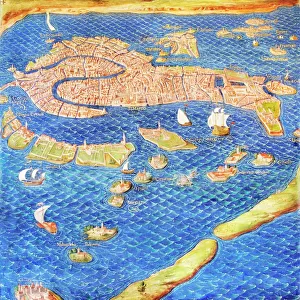
Atlas Novus. Europe, 17th c Venice
BLAEU, Jan (1596-1673). Atlas Novus or Atlas Maior. 1635 - 1665. Europa recens descripta. Map of Europe printed in Amsterdam ca. 1633. Detail of the city of Venice. Etching. SPAIN. CATALONIA. Barcelona. Biblioteca de Catalunya (National Library of Catalonia)
Mary Evans Picture Library makes available wonderful images created for people to enjoy over the centuries
Media ID 14179320
© Iberfoto/Mary Evans
1571 1596 1633 1635 1638 1665 1673 Adriatic Amsterdam Atlas Barcelona Biblioteca Blaeu Canal Cartographic Cartographies Cartography Catalonia Catalunya Channel Cities Engravings Etching Etchings Europa Janszoon Maior Monde Novus Venice Willem Descripta
12"x10" Modern Frame
Discover the rich history and intricate detail of Europe's past with our exquisite collection of Framed Prints from Media Storehouse. This captivating piece showcases "Atlas Novus. Europe, 17th c Venice" by Rights Managed from Mary Evans Prints Online. Originally created by the renowned cartographer Jan Blaeu in Amsterdam around 1633, this detailed etching of Venice, Europe's legendary city of trade and art, is a testament to the beauty and complexity of the Old World. Each print is expertly framed to preserve and enhance the intricacies of the etching, making it a stunning addition to any home or office. Bring a piece of history into your space with our Framed Prints, perfect for history enthusiasts, art collectors, or anyone seeking to add character and depth to their decor.
10x8 Print in an MDF Wooden Frame with 180 gsm Satin Finish Paper. Glazed using shatter proof thin plexi glass. Frame thickness is 1 inch and depth 0.75 inch. Fluted cardboard backing held with clips. Supplied ready to hang with sawtooth hanger and rubber bumpers. Spot clean with a damp cloth. Packaged foam wrapped in a card.
Contemporary Framed and Mounted Prints - Professionally Made and Ready to Hang
Estimated Image Size (if not cropped) is 25.4cm x 25.4cm (10" x 10")
Estimated Product Size is 30.5cm x 25.4cm (12" x 10")
These are individually made so all sizes are approximate
Artwork printed orientated as per the preview above, with landscape (horizontal) or portrait (vertical) orientation to match the source image.
FEATURES IN THESE COLLECTIONS
> Europe
> Spain
> Related Images
> Maps and Charts
> Willem Janszoon Blaeu
EDITORS COMMENTS
This detail is taken from the Atlas Novus, or Atlas Maior, a seminal work of cartography produced by the renowned Flemish cartographer Jan Blaeu and his team in Amsterdam around 1633. The map, titled Europa recens descripta, offers an intricately detailed representation of Europe during the 17th century. This particular section showcases the city of Venice, a cultural and commercial hub of the time. The etching, which is part of a larger atlas, displays the urban layout of the city, including its iconic Le Theatre du Monde, the Rialto Bridge, and the Grand Canal. Blaeu, who was born in the Netherlands but spent a significant portion of his life in Italy, drew upon the latest cartographic knowledge and techniques to create this masterpiece. The map was published during the height of the Dutch Golden Age, a period marked by significant advancements in cartography and exploration. The Atlas Novus was produced using the most advanced etching techniques of the time, resulting in a highly detailed and visually stunning representation of Europe. This map was part of a larger project, which included the publication of the Atlas Maior, an extensive atlas that covered the entire world. This section of the map, which is now housed in the Biblioteca de Catalunya (National Library of Catalonia) in Barcelona, Spain, offers a glimpse into the urban landscape of Venice during the 17th century. The map's intricate details, from the winding canals to the architectural features of the city, provide a fascinating window into the past and offer a reminder of the rich cartographic heritage of Europe.
MADE IN THE USA
Safe Shipping with 30 Day Money Back Guarantee
FREE PERSONALISATION*
We are proud to offer a range of customisation features including Personalised Captions, Color Filters and Picture Zoom Tools
SECURE PAYMENTS
We happily accept a wide range of payment options so you can pay for the things you need in the way that is most convenient for you
* Options may vary by product and licensing agreement. Zoomed Pictures can be adjusted in the Basket.