Poster Print > Arts > Artists > M > Thomas Moule
Poster Print : Old Map of Boston England 1836 by Thomas Moule


![]()
Poster Prints From MapSeeker
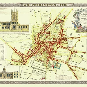
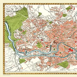
Old Map of Boston England 1836 by Thomas Moule
This is a fine decorative reproduction Map of The Town of Boston from the First Edition series of Thomas Moule Maps, originally Published in 1836
Welcome to the Mapseeker Image library and enter an historic gateway to one of the largest on-line collections of Historic Maps, Nostalgic Views, Vista's and Panorama's from a World gone by.
Media ID 20348268
Historic Map Moule Map Old Town Plan Thomas Moule Thomas Moule Map Town Plan Boston Boston City
18x24 inch Poster Print
Elevate your home or office decor with a piece of historical charm. Introducing the Media Storehouse Old Map of Boston England 1836 by Thomas Moule, a beautiful reproduction of an original map published in 1836. This fine decorative print showcases intricate details of The Town of Boston during that era, making it a fascinating addition to any space. With its antique appeal and rich history, this Old Map of Boston England 1836 by Thomas Moule is not just a print, but a window into the past. Order yours today and bring a piece of history into your home or office.
Poster prints are budget friendly enlarged prints in standard poster paper sizes. Printed on 150 gsm Matte Paper for a natural feel and supplied rolled in a tube. Great for framing and should last many years. To clean wipe with a microfiber, non-abrasive cloth or napkin. Our Archival Quality Photo Prints and Fine Art Paper Prints are printed on higher quality paper and the choice of which largely depends on your budget.
Poster prints are budget friendly enlarged prints in standard poster paper sizes (A0, A1, A2, A3 etc). Whilst poster paper is sometimes thinner and less durable than our other paper types, they are still ok for framing and should last many years. Our Archival Quality Photo Prints and Fine Art Paper Prints are printed on higher quality paper and the choice of which largely depends on your budget.
Estimated Product Size is 46.3cm x 61.6cm (18.2" x 24.3")
These are individually made so all sizes are approximate
Artwork printed orientated as per the preview above, with portrait (vertical) orientation to match the source image.
FEATURES IN THESE COLLECTIONS
> MapSeeker
> British Town And City Plans
> English & Welsh PORTFOLIO
> Arts
> Artists
> M
> Thomas Moule
> Europe
> United Kingdom
> England
> Maps
EDITORS COMMENTS
This stunning print showcases the Old Map of Boston, England from 1836, meticulously crafted by renowned cartographer Thomas Moule. A true collector's item, this fine decorative reproduction captures the essence of a bygone era and offers a fascinating glimpse into the town's rich history. Originally published in 1836 as part of Moule's First Edition series, this map is an exquisite representation of Boston during that time. With intricate details and precise craftsmanship, it provides a comprehensive overview of the town's layout and landmarks. The Town Plan of Boston depicted in this map reveals its charming streets lined with historic buildings and bustling markets. Every corner is filled with historical significance, transporting us back to a time when horse-drawn carriages roamed these cobblestone roads. As we explore this old city plan through Moule's eyes, we can imagine ourselves wandering along its waterfront or visiting St Botolph's Church - famously known as "The Stump". The map also highlights other notable features such as bridges crossing over River Witham and various public squares where community life thrived. Whether you are an avid historian or simply appreciate artistry from centuries past, this print will undoubtedly add character to any space. It serves as a reminder that beneath modernity lies layers upon layers of heritage waiting to be discovered.
MADE IN THE USA
Safe Shipping with 30 Day Money Back Guarantee
FREE PERSONALISATION*
We are proud to offer a range of customisation features including Personalised Captions, Color Filters and Picture Zoom Tools
SECURE PAYMENTS
We happily accept a wide range of payment options so you can pay for the things you need in the way that is most convenient for you
* Options may vary by product and licensing agreement. Zoomed Pictures can be adjusted in the Basket.