Fine Art Print > Arts > Artists > M > Thomas Moule
Fine Art Print : Old Map of Boston England 1836 by Thomas Moule


![]()
Fine Art Prints From MapSeeker
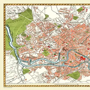
Old Map of Boston England 1836 by Thomas Moule
This is a fine decorative reproduction Map of The Town of Boston from the First Edition series of Thomas Moule Maps, originally Published in 1836
Welcome to the Mapseeker Image library and enter an historic gateway to one of the largest on-line collections of Historic Maps, Nostalgic Views, Vista's and Panorama's from a World gone by.
Media ID 20348268
Historic Map Moule Map Old Town Plan Thomas Moule Thomas Moule Map Town Plan Boston Boston City
20"x16" (+3" Border) Fine Art Print
Step back in time with our exquisite Old Map of Boston England 1836 by Thomas Moule from MapSeeker. This fine art print is a decorative reproduction of the first edition Thomas Moule Map, originally published in 1836. The intricate details of this antique map showcase the historical layout of Boston, England, making it a captivating addition to any home or office. With its rich, vibrant colors and authentic design, this fine art print is not only a beautiful piece of art but also a window into the past. Bring history to life with this stunning representation of Boston's past, perfect for history enthusiasts, collectors, or anyone who appreciates the beauty of vintage maps.
20x16 image printed on 26x22 Fine Art Rag Paper with 3" (76mm) white border. Our Fine Art Prints are printed on 300gsm 100% acid free, PH neutral paper with archival properties. This printing method is used by museums and art collections to exhibit photographs and art reproductions.
Our fine art prints are high-quality prints made using a paper called Photo Rag. This 100% cotton rag fibre paper is known for its exceptional image sharpness, rich colors, and high level of detail, making it a popular choice for professional photographers and artists. Photo rag paper is our clear recommendation for a fine art paper print. If you can afford to spend more on a higher quality paper, then Photo Rag is our clear recommendation for a fine art paper print.
Estimated Image Size (if not cropped) is 40.6cm x 50.8cm (16" x 20")
Estimated Product Size is 55.9cm x 66cm (22" x 26")
These are individually made so all sizes are approximate
Artwork printed orientated as per the preview above, with portrait (vertical) orientation to match the source image.
FEATURES IN THESE COLLECTIONS
> Arts
> Artists
> M
> Thomas Moule
> Europe
> United Kingdom
> England
> Maps
> MapSeeker
> British Town And City Plans
> English & Welsh PORTFOLIO
EDITORS COMMENTS
This stunning print showcases the Old Map of Boston, England from 1836, meticulously crafted by renowned cartographer Thomas Moule. A true collector's item, this fine decorative reproduction captures the essence of a bygone era and offers a fascinating glimpse into the town's rich history. Originally published in 1836 as part of Moule's First Edition series, this map is an exquisite representation of Boston during that time. With intricate details and precise craftsmanship, it provides a comprehensive overview of the town's layout and landmarks. The Town Plan of Boston depicted in this map reveals its charming streets lined with historic buildings and bustling markets. Every corner is filled with historical significance, transporting us back to a time when horse-drawn carriages roamed these cobblestone roads. As we explore this old city plan through Moule's eyes, we can imagine ourselves wandering along its waterfront or visiting St Botolph's Church - famously known as "The Stump". The map also highlights other notable features such as bridges crossing over River Witham and various public squares where community life thrived. Whether you are an avid historian or simply appreciate artistry from centuries past, this print will undoubtedly add character to any space. It serves as a reminder that beneath modernity lies layers upon layers of heritage waiting to be discovered.
MADE IN THE USA
Safe Shipping with 30 Day Money Back Guarantee
FREE PERSONALISATION*
We are proud to offer a range of customisation features including Personalised Captions, Color Filters and Picture Zoom Tools
SECURE PAYMENTS
We happily accept a wide range of payment options so you can pay for the things you need in the way that is most convenient for you
* Options may vary by product and licensing agreement. Zoomed Pictures can be adjusted in the Basket.