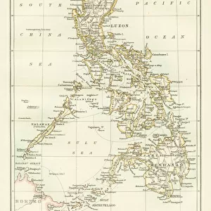
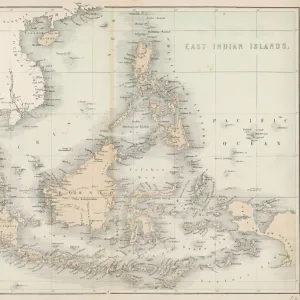
Poster Print : 1801, Cary Map of the East Indies and Southeast Asia, Singapore, Borneo, Sumatra


![]()
Poster Prints from Liszt Collection
1801, Cary Map of the East Indies and Southeast Asia, Singapore, Borneo, Sumatra
1801, Cary Map of the East Indies and Southeast Asia, Singapore, Borneo, Sumatra, Java, Philippines, John Cary, 1754 - 1835, English cartographer
Liszt Collection of nineteenth-century engravings and images to browse and enjoy
Media ID 14004878
© Artokoloro Quint Lox Limited
1754 1835 1754 – 1835 17541835 1801 Borneo English Cartographer Java John Cary Philippines Singapore Sumatra Antique Map Latitude Longitude Mappa Mundi Old Antique Plan Old Antique View Ols Antique Map Rare Old Maps Topo
27x27 inch Poster Print
Discover the rich history of maritime exploration with our stunning Media Storehouse Poster Print of the 1801 Cary Map of the East Indies and Southeast Asia. This captivating vintage map, hailing from the esteemed Liszt Collection, showcases intricate detailing of the East Indies and Southeast Asian regions, including Singapore, Borneo, Sumatra, Java, and the Philippines. English cartographer John Cary meticulously crafted this masterpiece in 1801, providing an authentic snapshot of geographical knowledge during that era. Elevate your home or office decor while delving into the fascinating history of cartography. Each print is produced using high-quality materials and vibrant colors, ensuring a beautiful and long-lasting addition to your space.
Poster prints are budget friendly enlarged prints in standard poster paper sizes. Printed on 150 gsm Matte Paper for a natural feel and supplied rolled in a tube. Great for framing and should last many years. To clean wipe with a microfiber, non-abrasive cloth or napkin. Our Archival Quality Photo Prints and Fine Art Paper Prints are printed on higher quality paper and the choice of which largely depends on your budget.
Poster prints are budget friendly enlarged prints in standard poster paper sizes (A0, A1, A2, A3 etc). Whilst poster paper is sometimes thinner and less durable than our other paper types, they are still ok for framing and should last many years. Our Archival Quality Photo Prints and Fine Art Paper Prints are printed on higher quality paper and the choice of which largely depends on your budget.
Estimated Product Size is 69.2cm x 69.2cm (27.2" x 27.2")
These are individually made so all sizes are approximate
Artwork printed orientated as per the preview above, with landscape (horizontal) or portrait (vertical) orientation to match the source image.
EDITORS COMMENTS
This vintage print showcases the intricate details of the 1801 Cary Map of the East Indies and Southeast Asia. Created by John Cary, a renowned English cartographer, this map offers a fascinating glimpse into the geography and topography of Singapore, Borneo, Sumatra, Java, and the Philippines during that era. The expertly illustrated landforms and geographic features are beautifully depicted on this aged paper artwork. The grid lines marking latitude and longitude add a touch of precision to this historical piece. As you explore this ancient map, you can almost envision the adventurous journeys taken by explorers who relied on such charts for navigation. With its decorative elements and artistic flair, this print serves as a testament to both history and artistry. It transports us back in time to an era when maps were not just tools for exploration but also works of art in their own right. Whether you are a lover of history or simply appreciate beautiful craftsmanship, this rare antique map from the Liszt Collection is sure to captivate your imagination. Display it proudly in your home or office as a conversation starter or use it as inspiration for your next travel adventure through these enchanting regions that have been shaped by centuries of discovery and exploration.
MADE IN THE USA
Safe Shipping with 30 Day Money Back Guarantee
FREE PERSONALISATION*
We are proud to offer a range of customisation features including Personalised Captions, Color Filters and Picture Zoom Tools
SECURE PAYMENTS
We happily accept a wide range of payment options so you can pay for the things you need in the way that is most convenient for you
* Options may vary by product and licensing agreement. Zoomed Pictures can be adjusted in the Cart.