Home > Arts > Artists > A > Battista Agnese
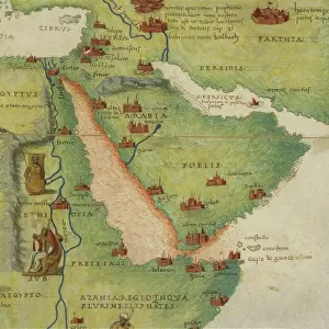
Magellans route, 16th century map

![]()
Wall Art and Photo Gifts from Science Photo Library
Magellans route, 16th century map
Magellans route around the world, in a 1544 copy of the Agnese Atlas. Magellans route is shown as a dark line. Ferdinand Magellan (c.1480-1521) set sail from Seville, Spain, in August 1519 with five ships. He sailed south and west around the tip of South America and then sailed for 100 days across the Pacific. Magellan died in the Philippines, and only a single ship completed the circumnavigation, returning to Spain in September 1522. The lighter line shows a route across the Atlantic from Spain to Central America and then to Peru. Twelve wind cherubs are also shown. This atlas was produced in Venice by Italian mapmaker Battista Agnese. The US Library of Congress acquired this edition in 1943
Science Photo Library features Science and Medical images including photos and illustrations
Media ID 6351815
© LIBRARY OF CONGRESS, GEOGRAPHY AND MAP DIVISION/SCIENCE PHOTO LIBRARY
1500s 16th Century Africa Age Of Discovery America Ancient Atlantic Atlas Book Cartography Circling Circumnavigation Continent Continents Diagram Discovering Discovery Eurasia Exploration Explorer Exploring Global Globe Inaccurate Incomplete Italian Navigation Navigator New World Old World Pacific Ocean Pioneer Pioneering Renaissance Route Spain Spanish Voyage Wind Winds World 1519 1520 1521 1522 1544 Circled Circumnavigating Ferdinand Magellan Library Of Congress Magellan
EDITORS COMMENTS
This print showcases Magellan's route, a significant 16th-century map that depicts his groundbreaking journey around the world. In this particular 1544 copy of the Agnese Atlas, Magellan's route is represented by a dark line, tracing his remarkable expedition. Ferdinand Magellan, an intrepid explorer born around 1480, embarked on this audacious voyage from Seville, Spain in August 1519 with five ships. He navigated south and westward around the tip of South America before embarking on a daunting 100-day crossing of the Pacific Ocean. Tragically, Magellan met his demise in the Philippines; however, one ship managed to complete the circumnavigation and returned to Spain in September 1522. The lighter line depicted on the map illustrates another route across the Atlantic from Spain to Central America and then onwards to Peru. The Agnese Atlas was meticulously crafted by Italian mapmaker Battista Agnese and produced in Venice during this era of great exploration and discovery. This edition was acquired by the US Library of Congress in 1943 as part of their extensive collection. This extraordinary artwork not only provides historical insight into Magellan's pioneering navigation but also offers a glimpse into ancient cartography techniques. It serves as a testament to human curiosity and determination during an age when much of our planet remained uncharted territory.
MADE IN THE USA
Safe Shipping with 30 Day Money Back Guarantee
FREE PERSONALISATION*
We are proud to offer a range of customisation features including Personalised Captions, Color Filters and Picture Zoom Tools
SECURE PAYMENTS
We happily accept a wide range of payment options so you can pay for the things you need in the way that is most convenient for you
* Options may vary by product and licensing agreement. Zoomed Pictures can be adjusted in the Cart.