Poster Print > Europe > United Kingdom > Wales > Maps
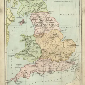
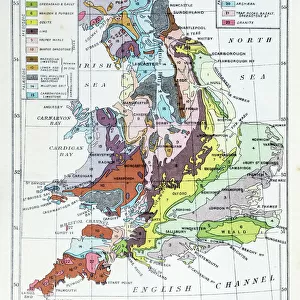
Poster Print : England and wales map 1895


![]()
Poster Prints from Fine Art Storehouse
England and wales map 1895
Meyers Konversations-Lexikon. Ein Nachschlagewerk des allgemeinen Wissens, 5th edition 17 volumes Bibliographisches Institut - Leipzig 1895-1897
Unleash your creativity and transform your space into a visual masterpiece!
THEPALMER
Media ID 13669565
© This content is subject to copyright
18x24 inch Poster Print
Introducing the captivating England and Wales Map 1895 from our Media Storehouse Poster Prints collection. This exquisite piece of history is brought to you from the pages of Meyers Konversations-Lexikon, the comprehensive reference work of general knowledge published by Bibliographisches Institut in Leipzig between 1895 and 1897. The map, created by THEPALMER, beautifully illustrates the geography of England and Wales during that era. Each detail, from the intricate border designs to the meticulously drawn counties and cities, adds to the authenticity and historical significance of this stunning print. Elevate your home or office decor with a touch of vintage charm and educational value.
Poster prints are budget friendly enlarged prints in standard poster paper sizes. Printed on 150 gsm Matte Paper for a natural feel and supplied rolled in a tube. Great for framing and should last many years. To clean wipe with a microfiber, non-abrasive cloth or napkin. Our Archival Quality Photo Prints and Fine Art Paper Prints are printed on higher quality paper and the choice of which largely depends on your budget.
Poster prints are budget friendly enlarged prints in standard poster paper sizes (A0, A1, A2, A3 etc). Whilst poster paper is sometimes thinner and less durable than our other paper types, they are still ok for framing and should last many years. Our Archival Quality Photo Prints and Fine Art Paper Prints are printed on higher quality paper and the choice of which largely depends on your budget.
Estimated Product Size is 46.3cm x 61.6cm (18.2" x 24.3")
These are individually made so all sizes are approximate
Artwork printed orientated as per the preview above, with portrait (vertical) orientation to match the source image.
FEATURES IN THESE COLLECTIONS
> Fine Art Storehouse
> The Magical World of Illustration
> Palmer Illustrated Collection
> Fine Art Storehouse
> Map
> Historical Maps
> Europe
> Related Images
> Europe
> United Kingdom
> England
> Maps
> Europe
> United Kingdom
> England
> Posters
> Europe
> United Kingdom
> England
> Related Images
> Europe
> United Kingdom
> Maps
> Europe
> United Kingdom
> Wales
> Maps
> Europe
> United Kingdom
> Wales
> Posters
> Europe
> United Kingdom
> Wales
> Related Images
> Maps and Charts
> Geological Map
> Maps and Charts
> Related Images
EDITORS COMMENTS
This print takes us back in time to the year 1895, showcasing an exquisite map of England and Wales. Derived from Meyers Konversations-Lexikon, a renowned encyclopedia series published between 1895 and 1897, this particular edition is the fifth and spans across an impressive seventeen volumes. The Bibliographisches Institut in Leipzig was responsible for bringing forth this treasure trove of knowledge. The map itself serves as a testament to the meticulous artistry of cartography during that era. Its vertical orientation allows for a comprehensive view of both countries, highlighting their intricate geological features with remarkable precision. Every contour and detail has been skillfully etched into existence through engraving techniques, resulting in an illustration that exudes elegance. As we gaze upon this antique masterpiece, it transports us to a bygone era when geologists meticulously studied the Earth's composition. It evokes a sense of wonderment at how our understanding of geology has evolved over time. While its historical significance cannot be denied, let us not forget the artistic prowess behind its creation. The craftsmanship displayed within this print is truly awe-inspiring; each stroke tells a story about the dedication and passion poured into its making. "The England and Wales Map 1895" by THEPALMER offers viewers a glimpse into both history and artistry simultaneously—a timeless piece that encapsulates centuries-old knowledge within its delicate engravings.
MADE IN THE USA
Safe Shipping with 30 Day Money Back Guarantee
FREE PERSONALISATION*
We are proud to offer a range of customisation features including Personalised Captions, Color Filters and Picture Zoom Tools
SECURE PAYMENTS
We happily accept a wide range of payment options so you can pay for the things you need in the way that is most convenient for you
* Options may vary by product and licensing agreement. Zoomed Pictures can be adjusted in the Cart.