Home > Europe > United Kingdom > England > Maps
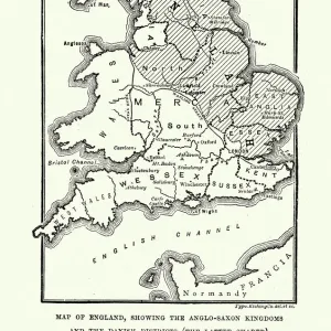
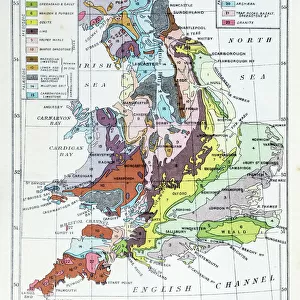
Old map of England after treaty of Chippenham in 878

![]()
Wall Art and Photo Gifts from Fine Art Storehouse
Old map of England after treaty of Chippenham in 878
Antique Illustration, Copyright has expired on this artwork. From my own archives, digitally restored.
The Battle of Chippenham was a January 878 battle between a Viking army led by Guthrum and an Anglo-Saxon army led by Alfred the Great
Unleash your creativity and transform your space into a visual masterpiece!
mikroman6
Media ID 25128151
© 2014-2020 Tomasz Skoczen
FEATURES IN THESE COLLECTIONS
> Arts
> Artists
> D
> Alfred
> Related Images
> Europe
> United Kingdom
> England
> Maps
> Fine Art Storehouse
> Map
> Historical Maps
> Maps and Charts
> Early Maps
EDITORS COMMENTS
This print transports us back in time to the aftermath of the historic Treaty of Chippenham in 878. The old map of England, beautifully illustrated with intricate details, reveals the territorial changes that occurred as a result of this significant event. With its copyright expired, we are fortunate to have access to this antique artwork from the personal archives of mikroman6. The Battle of Chippenham, depicted on this map, was a momentous clash between Viking invaders led by Guthrum and an Anglo-Saxon army commanded by none other than Alfred the Great. This battle marked a turning point in English history as it ultimately paved the way for Alfred's eventual victory over the Vikings and his subsequent reign as one of England's most revered monarchs. Thanks to digital restoration techniques employed by mikroman6, every line and contour on this aged illustration has been meticulously revived. As we gaze upon this piece, we can't help but marvel at how it offers us a glimpse into a long-gone era when kingdoms were forged through bloodshed and diplomacy. Whether you're an avid historian or simply appreciate art that tells stories from our past, this print serves as both an educational tool and a visual delight. Let your imagination wander as you explore the intricacies within each corner of this ancient map – truly a treasure worth cherishing for generations to come.
MADE IN THE USA
Safe Shipping with 30 Day Money Back Guarantee
FREE PERSONALISATION*
We are proud to offer a range of customisation features including Personalised Captions, Color Filters and Picture Zoom Tools
SECURE PAYMENTS
We happily accept a wide range of payment options so you can pay for the things you need in the way that is most convenient for you
* Options may vary by product and licensing agreement. Zoomed Pictures can be adjusted in the Cart.