Pillow : Middle East at night, satellite image
![]()

Home Decor from Science Photo Library
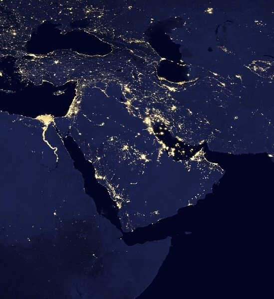
Middle East at night, satellite image
Middle East at night. Black marble satellite image of the Arabian peninsula at night. More densely populated areas are brighter. Gas flares from oil and gas fields are also seen. Data acquired by the day-night band of the Visible Infrared Imaging Radiometer Suite (VIIRS) on board the NASA-NOa Suomi National Polar-orbiting Partnership (NPP) satellite, over nine days in April 2012 and 13 days in October 2012
Science Photo Library features Science and Medical images including photos and illustrations
Media ID 9221753
© NASA EARTH OBSERVATORY/NOAA NGDC/SCIENCE PHOTO LIBRARY
2012 Africa African Arabian Peninsula Black Marble Cities City Composite Image Continent Dark Day Night Band Earth Observation Electricity Energy Use Flat Projection From Space Habitation Illuminate Illumination Land Light Light Pollution Lights Middle East Middle Eastern Night Night Time Nile Nile Delta Population Density River Rural Satellite Satellite Image Suomi Npp Urban Viirs
18"x18" (46x46cm) Pillow
18"x18" (46x46cm) Faux Suede Pillow with a plush soft feel. Your choice of image fills the front, with a stone colored faux suede back. Flat sewn concealed white zip.
Accessorise your space with decorative, soft pillows
Estimated Product Size is 45.7cm x 45.7cm (18" x 18")
These are individually made so all sizes are approximate
Artwork printed orientated as per the preview above, with landscape (horizontal) or portrait (vertical) orientation to match the source image.
EDITORS COMMENTS
This print showcases the Middle East at night, revealing a mesmerizing satellite image of the Arabian peninsula. The black marble effect beautifully highlights the stark contrast between densely populated areas and more rural regions. As our eyes wander across this stunning visual, we witness brighter spots representing bustling cities and towns, while gas flares from oil and gas fields illuminate the landscape. The data for this extraordinary image was acquired by NASA-NOa Suomi National Polar-orbiting Partnership (NPP) satellite's day-night band of the Visible Infrared Imaging Radiometer Suite (VIIRS). Over nine days in April 2012 and thirteen days in October 2012, this state-of-the-art technology captured an awe-inspiring view of Earth from space. One cannot help but be captivated by the intricate web of lights that adorn this composite image. From Africa's Nile Delta to vibrant urban centers across the Middle East, these lights symbolize human habitation and energy use on a grand scale. However, they also shed light on another pressing issue – light pollution. As we marvel at this snapshot taken during the 21st century era of earth observation, let us reflect upon how our actions impact our planet. This remarkable photograph serves as a reminder to appreciate both the beauty and fragility of our world.
MADE IN THE USA
Safe Shipping with 30 Day Money Back Guarantee
FREE PERSONALISATION*
We are proud to offer a range of customisation features including Personalised Captions, Color Filters and Picture Zoom Tools
SECURE PAYMENTS
We happily accept a wide range of payment options so you can pay for the things you need in the way that is most convenient for you
* Options may vary by product and licensing agreement. Zoomed Pictures can be adjusted in the Cart.


