Pillow > Arts > Artists > B > Willem Blaeu
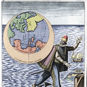
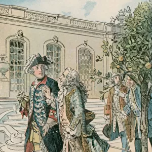
Pillow : Measurement of the Earth. Detail of the atlas by Willem Janszoon Blaeu (1571-1638)
")
")

![]()
Home Decor from Fine Art Finder
Measurement of the Earth. Detail of the atlas by Willem Janszoon Blaeu (1571-1638)
GIA4777406 Measurement of the Earth. Detail of the atlas by Willem Janszoon Blaeu (1571-1638). Amsterdam 1630. by Blaeu, Willem (1571-1638); Private Collection; (add.info.: Measurement of the Earth. Detail of the atlas by Willem Janszoon Blaeu (1571-1638). Amsterdam 1630.); eGiancarlo Costa; Dutch, out of copyright
Media ID 22290940
© Giancarlo Costa / Bridgeman Images
Comppas Earth Earth Globe Meter Monkey Planisphere Geographer Geographical Map
18"x18" (46x46cm) Pillow
18"x18" (46x46cm) Faux Suede Pillow with a plush soft feel. Your choice of image fills the front, with a stone colored faux suede back. Flat sewn concealed white zip.
Accessorise your space with decorative, soft pillows
Estimated Product Size is 45.7cm x 45.7cm (18" x 18")
These are individually made so all sizes are approximate
Artwork printed orientated as per the preview above, with landscape (horizontal) or portrait (vertical) orientation to match the source image.
FEATURES IN THESE COLLECTIONS
> Fine Art Finder
> Artists
> Antonio Visentini
> Fine Art Finder
> Artists
> Willem Blaeu
> Arts
> Artists
> B
> Willem Blaeu
> Maps and Charts
> Related Images
> Maps and Charts
> Willem Janszoon Blaeu
> Maps and Charts
> World
EDITORS COMMENTS
This print showcases a remarkable detail from the atlas created by Willem Janszoon Blaeu in 1630. Titled "Measurement of the Earth" this exquisite piece offers a glimpse into the intricate world of cartography during the 17th century. The image depicts an allegorical scene, with a geographer diligently measuring and mapping the earth's surface. The use of various instruments, such as a compass and planisphere, highlights the precision and scientific approach employed by Blaeu in his work. Notably, amidst this scholarly setting, an unexpected element adds whimsy to the composition - a mischievous monkey curiously observes the geographer's activities. This playful addition serves as a reminder that even in serious pursuits like geography, there is room for lightheartedness and curiosity. Giancarlo Costa expertly captures this extraordinary artwork through his lens, allowing us to appreciate every intricate detail. The rich colors and fine engravings bring forth both beauty and historical significance. As we gaze upon this photo print, we are transported back in time to witness Blaeu's dedication to accurately representing our vast world on paper. It is truly awe-inspiring to consider how far our understanding of geography has come since then. This stunning piece would make an excellent addition to any art collection or serve as an educational tool for those fascinated by history or cartography.
MADE IN THE USA
Safe Shipping with 30 Day Money Back Guarantee
FREE PERSONALISATION*
We are proud to offer a range of customisation features including Personalised Captions, Color Filters and Picture Zoom Tools
SECURE PAYMENTS
We happily accept a wide range of payment options so you can pay for the things you need in the way that is most convenient for you
* Options may vary by product and licensing agreement. Zoomed Pictures can be adjusted in the Cart.