Home > Europe > Italy > Veneto > Venice
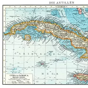
View of the island of Cuba. Isolario (map of islands) by Benedetto Bordone. Venice 1547
 by Benedetto Bordone. Venice 1547")
![]()
Wall Art and Photo Gifts from Fine Art Finder
View of the island of Cuba. Isolario (map of islands) by Benedetto Bordone. Venice 1547
GIA4784032 View of the island of Cuba. Isolario (map of islands) by Benedetto Bordone. Venice 1547 by Italian School, (16th century); Private Collection; (add.info.: View of the island of Cuba. Isolario (map of islands) by Benedetto Bordone. Venice 1547); eGiancarlo Costa; Italian, out of copyright
Media ID 23715086
© Giancarlo Costa / Bridgeman Images
Atlantic Ocean Central America Cuba Cuban Geographical Map
FEATURES IN THESE COLLECTIONS
> Arts
> Artists
> I
> Italian School Italian School
> Europe
> Italy
> Veneto
> Venice
> Fine Art Finder
> Artists
> Italian School
> Fine Art Finder
> Artists
> Theodore de Bry
> Maps and Charts
> Italy
> Maps and Charts
> Related Images
> North America
> Cuba
> Maps
> North America
> Cuba
> Related Images
EDITORS COMMENTS
This print showcases a historical map titled "View of the island of Cuba. Isolario (map of islands)" by Benedetto Bordone, dating back to 1547 in Venice. The Italian School from the 16th century created this remarkable piece, which now resides in a private collection. The engraving depicts an intricate and detailed representation of Cuba, offering viewers a glimpse into the exploration and geographical understanding during that era. This map is not only a testament to colonialism but also serves as an invaluable resource for studying the discovery and development of this American island. Benedetto Bordone's work highlights his expertise in cartography, showcasing his meticulous attention to detail and accuracy. As we delve into this image, we are transported back in time to witness the beauty and complexity of Central America through an Italian lens. The vastness of the Atlantic Ocean surrounding Cuba adds depth to this composition, emphasizing its isolation yet highlighting its significance within global trade routes during that period. Giancarlo Costa's expert photography captures every nuance with precision while preserving the essence and charm exuded by this ancient artwork. This photograph is not just a visual delight; it represents centuries-old knowledge passed down through generations. It invites us to appreciate both artistry and history simultaneously while shedding light on our ever-evolving understanding of geography and exploration.
MADE IN THE USA
Safe Shipping with 30 Day Money Back Guarantee
FREE PERSONALISATION*
We are proud to offer a range of customisation features including Personalised Captions, Color Filters and Picture Zoom Tools
SECURE PAYMENTS
We happily accept a wide range of payment options so you can pay for the things you need in the way that is most convenient for you
* Options may vary by product and licensing agreement. Zoomed Pictures can be adjusted in the Cart.