Photographic Print > Europe > Portugal > Maps
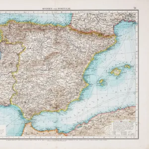
Photographic Print : Medieval Spain and Portugal map


Photo Prints From North Wind
Medieval Spain and Portugal map
Map of the Iberian Peninsula in the 1300s and 1400s.
Printed color lithograph reproduction of a 19th-century illustration
North Wind Picture Archives brings history to life with stock images and hand-colored illustrations
Media ID 5882217
© North Wind Picture Archives
1300s 1400s 14th Century 15th Century Europe European Granada Medieval Middle Ages Moors Portugal Portuguese Spain Spanish Aragon Castile Gibraltar Iberia Iberian Peninsula Navarra
10"x8" Photo Print
Discover the rich history of Medieval Spain and Portugal with our stunningly detailed and vibrant Photographic Print from Media Storehouse. This captivating map, taken from the North Wind Picture Archives, transports you back in time to the 1300s and 1400s. Printed using color lithography, this reproduction of an original 19th-century illustration showcases the intricacies of the Iberian Peninsula during this fascinating era. Add an authentic and educational touch to your home or office decor with this beautiful, high-quality print.
Photo prints are produced on Kodak professional photo paper resulting in timeless and breath-taking prints which are also ideal for framing. The colors produced are rich and vivid, with accurate blacks and pristine whites, resulting in prints that are truly timeless and magnificent. Whether you're looking to display your prints in your home, office, or gallery, our range of photographic prints are sure to impress. Dimensions refers to the size of the paper in inches.
Our Photo Prints are in a large range of sizes and are printed on Archival Quality Paper for excellent colour reproduction and longevity. They are ideal for framing (our Framed Prints use these) at a reasonable cost. Alternatives include cheaper Poster Prints and higher quality Fine Art Paper, the choice of which is largely dependant on your budget.
Estimated Image Size (if not cropped) is 25.4cm x 17.7cm (10" x 7")
Estimated Product Size is 25.4cm x 20.3cm (10" x 8")
These are individually made so all sizes are approximate
Artwork printed orientated as per the preview above, with landscape (horizontal) orientation to match the source image.
FEATURES IN THESE COLLECTIONS
> Arts
> Art Movements
> Medieval Art
> Europe
> Portugal
> Related Images
> Europe
> Spain
> Related Images
> Maps and Charts
> Related Images
EDITORS COMMENTS
This print takes us on a journey back in time to the medieval era of Spain and Portugal. With its vibrant colors and intricate details, it beautifully captures the essence of the Iberian Peninsula during the 1300s and 1400s. The map showcases the rich history and heritage of this region, highlighting key cities such as Granada, Gibraltar, Aragon, Castile, Navarra, and more. Each city is marked with precision, allowing us to trace the footsteps of ancient civilizations that once thrived here. As we explore this vintage illustration, we are transported to a world where traditional architecture meets European charm. The artistry behind this lithograph reproduction truly brings out the grandeur of medieval Spain and Portugal. One cannot help but marvel at how this map encapsulates centuries of cultural exchange between Christians and Moors. It serves as a testament to their coexistence during these tumultuous times in history. Whether you are an art enthusiast or a history buff, this print offers a glimpse into Europe's fascinating past. It serves as a reminder that even amidst political turmoil and territorial disputes, beauty can be found in every corner of our shared human experience
MADE IN THE USA
Safe Shipping with 30 Day Money Back Guarantee
FREE PERSONALISATION*
We are proud to offer a range of customisation features including Personalised Captions, Color Filters and Picture Zoom Tools
SECURE PAYMENTS
We happily accept a wide range of payment options so you can pay for the things you need in the way that is most convenient for you
* Options may vary by product and licensing agreement. Zoomed Pictures can be adjusted in the Basket.