Photographic Print > Europe > United Kingdom > Scotland > Maps
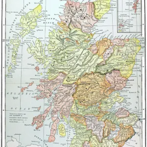
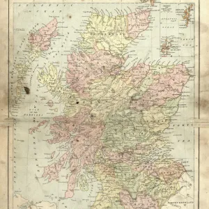
Photographic Print : Scotland map, 1870s


Photo Prints from North Wind
Scotland map, 1870s
Map of Scotland, 1870s.
Printed color lithograph
North Wind Picture Archives brings history to life with stock images and hand-colored illustrations
Media ID 5879180
© North Wind Picture Archives
1870s British British Isles Europe European Great Britain Scot Land Scottish Territory
10"x8" Photo Print
Discover the rich history of Scotland with our exquisite Media Storehouse Photographic Print of a map from the 1870s. Meticulously sourced from the North Wind Picture Archives, this printed color lithograph transports you back in time, offering a fascinating glimpse into the cartography of a bygone era. Ideal for history enthusiasts, collectors, or those with a deep connection to Scotland, this vintage map print makes a stunning addition to any home or office décor. Bring a piece of the past into your present with our authentic and beautifully preserved photographic print.
Photo prints are produced on Kodak professional photo paper resulting in timeless and breath-taking prints which are also ideal for framing. The colors produced are rich and vivid, with accurate blacks and pristine whites, resulting in prints that are truly timeless and magnificent. Whether you're looking to display your prints in your home, office, or gallery, our range of photographic prints are sure to impress. Dimensions refers to the size of the paper in inches.
Our Photo Prints are in a large range of sizes and are printed on Archival Quality Paper for excellent colour reproduction and longevity. They are ideal for framing (our Framed Prints use these) at a reasonable cost. Alternatives include cheaper Poster Prints and higher quality Fine Art Paper, the choice of which is largely dependant on your budget.
Estimated Product Size is 20.3cm x 25.4cm (8" x 10")
These are individually made so all sizes are approximate
Artwork printed orientated as per the preview above, with landscape (horizontal) or portrait (vertical) orientation to match the source image.
FEATURES IN THESE COLLECTIONS
> North Wind Picture Archives
> British history
> North Wind Picture Archives
> Maps
> Europe
> France
> Canton
> Landes
> Europe
> United Kingdom
> Maps
> Europe
> United Kingdom
> Scotland
> Maps
> Europe
> United Kingdom
> Scotland
> Posters
> Europe
> United Kingdom
> Scotland
> Related Images
> Maps and Charts
> Related Images
> Popular Themes
> Maps and Charts
EDITORS COMMENTS
This stunning vintage print showcases a meticulously detailed map of Scotland, dating back to the 1870s. The rich hues of printed color lithography bring this piece to life, capturing the essence of Scottish heritage and tradition. The map itself is a testament to the historic significance of Scotland within Great Britain and Europe as a whole. Every contour, river, and town is intricately illustrated, providing an invaluable glimpse into the territory's past. This artwork serves as a visual time capsule from the 19th century, offering viewers a chance to explore British history through cartography. As we gaze upon this print, we are transported back in time to an era when maps were not just navigational tools but works of art themselves. The attention to detail and artistic flair evident in this piece truly make it stand out. Whether you have personal ties to Scotland or simply appreciate historical artifacts, this print is sure to captivate your imagination. It serves as a reminder that even in our modern world dominated by GPS systems and digital mapping technologies, there is still something enchanting about holding a physical representation of our past. Displaying this magnificent map on your wall will not only add character and charm but also spark conversations about history and geography for years to come.
MADE IN THE USA
Safe Shipping with 30 Day Money Back Guarantee
FREE PERSONALISATION*
We are proud to offer a range of customisation features including Personalised Captions, Color Filters and Picture Zoom Tools
SECURE PAYMENTS
We happily accept a wide range of payment options so you can pay for the things you need in the way that is most convenient for you
* Options may vary by product and licensing agreement. Zoomed Pictures can be adjusted in the Cart.