Jigsaw Puzzle > Europe > United Kingdom > Scotland > Maps
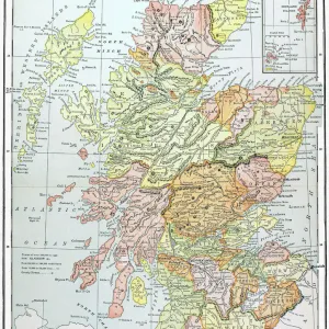
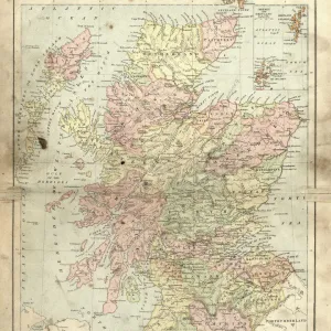
Jigsaw Puzzle : Scotland map, 1870s


Jigsaw Puzzles from North Wind
Scotland map, 1870s
Map of Scotland, 1870s.
Printed color lithograph
North Wind Picture Archives brings history to life with stock images and hand-colored illustrations
Media ID 5879180
© North Wind Picture Archives
1870s British British Isles Europe European Great Britain Scot Land Scottish Territory
Jigsaw Puzzle (520 Pieces)
Discover the rich history of Scotland with our exquisite jigsaw puzzle from Media Storehouse, featuring a captivating image of an 1870s map of Scotland from North Wind Picture Archives. This intricately detailed, printed color lithograph puzzle transports you back in time, allowing you to explore the contours and boundaries of Scotland as they were over a century ago. Immerse yourself in the puzzle-solving experience and uncover the stories hidden within the intricate lines and vibrant colors of this fascinating piece of historical cartography. Perfect for history enthusiasts, puzzle lovers, or anyone seeking a challenging and rewarding pastime, this Scotland map puzzle is a must-have addition to your collection.
Made in the USA, 520-piece puzzles measure 16" x 20" (40.6 x 50.8 cm). Every puzzle is meticulously printed on glossy photo paper, which has a strong 1.33 mm thickness. Delivered in a black storage cardboard box, these puzzles are both stylish and practical. (Note: puzzles contain small parts and are not suitable for children under 3 years of age.)
Jigsaw Puzzles are an ideal gift for any occasion
Estimated Product Size is 40.5cm x 50.8cm (15.9" x 20")
These are individually made so all sizes are approximate
Artwork printed orientated as per the preview above, with landscape (horizontal) or portrait (vertical) orientation to match the source image.
FEATURES IN THESE COLLECTIONS
> Europe
> France
> Canton
> Landes
> Europe
> United Kingdom
> Maps
> Europe
> United Kingdom
> Scotland
> Maps
> Europe
> United Kingdom
> Scotland
> Posters
> Europe
> United Kingdom
> Scotland
> Related Images
> Maps and Charts
> Related Images
> Popular Themes
> Maps and Charts
> North Wind Picture Archives
> British history
> North Wind Picture Archives
> Maps
EDITORS COMMENTS
This stunning vintage print showcases a meticulously detailed map of Scotland, dating back to the 1870s. The rich hues of printed color lithography bring this piece to life, capturing the essence of Scottish heritage and tradition. The map itself is a testament to the historic significance of Scotland within Great Britain and Europe as a whole. Every contour, river, and town is intricately illustrated, providing an invaluable glimpse into the territory's past. This artwork serves as a visual time capsule from the 19th century, offering viewers a chance to explore British history through cartography. As we gaze upon this print, we are transported back in time to an era when maps were not just navigational tools but works of art themselves. The attention to detail and artistic flair evident in this piece truly make it stand out. Whether you have personal ties to Scotland or simply appreciate historical artifacts, this print is sure to captivate your imagination. It serves as a reminder that even in our modern world dominated by GPS systems and digital mapping technologies, there is still something enchanting about holding a physical representation of our past. Displaying this magnificent map on your wall will not only add character and charm but also spark conversations about history and geography for years to come.
MADE IN THE USA
Safe Shipping with 30 Day Money Back Guarantee
FREE PERSONALISATION*
We are proud to offer a range of customisation features including Personalised Captions, Color Filters and Picture Zoom Tools
SECURE PAYMENTS
We happily accept a wide range of payment options so you can pay for the things you need in the way that is most convenient for you
* Options may vary by product and licensing agreement. Zoomed Pictures can be adjusted in the Cart.