Photographic Print : Proposed extensions of transport links into London 1919


![]()
Photo Prints from Mary Evans Picture Library
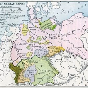
Proposed extensions of transport links into London 1919
Diagram showing a map of London and the movement of commuters by different travel means from Greater to Central London, and the proposed extensions of transport links and increase of capacity of buses and vehicles.
1919
Mary Evans Picture Library makes available wonderful images created for people to enjoy over the centuries
Media ID 14387508
© Mary Evans Picture Library
Commute Commuters Commuting Diagram Double Extension Greater Hour Hours Improve Improvement Improvements Improving Journey Maps Mar16 Ministry Network Outer Passengers Plan Plans Population Proposals Railways Route Routes Rush Spread Traffic Trains Travelling Tube Tubes Underground Vehicles 1919
10"x8" Photo Print
Step back in time and explore the visionary transport plans of 1919 with our stunning print from Mary Evans Picture Library. This captivating image, titled "Proposed extensions of transport links into London 1919," offers a unique glimpse into the future of London's transportation system. The diagram showcases the bustling movement of commuters from Greater to Central London via various modes of transport. Witness the intricate details of proposed extensions and expansions that shaped the city's transport infrastructure, making this print an essential addition to any history or transportation enthusiast's collection.
Photo prints are produced on Kodak professional photo paper resulting in timeless and breath-taking prints which are also ideal for framing. The colors produced are rich and vivid, with accurate blacks and pristine whites, resulting in prints that are truly timeless and magnificent. Whether you're looking to display your prints in your home, office, or gallery, our range of photographic prints are sure to impress. Dimensions refers to the size of the paper in inches.
Our Photo Prints are in a large range of sizes and are printed on Archival Quality Paper for excellent colour reproduction and longevity. They are ideal for framing (our Framed Prints use these) at a reasonable cost. Alternatives include cheaper Poster Prints and higher quality Fine Art Paper, the choice of which is largely dependant on your budget.
Estimated Image Size (if not cropped) is 25.4cm x 17.7cm (10" x 7")
Estimated Product Size is 25.4cm x 20.3cm (10" x 8")
These are individually made so all sizes are approximate
Artwork printed orientated as per the preview above, with landscape (horizontal) orientation to match the source image.
EDITORS COMMENTS
1919: Proposed Extensions of Transport Links into London - A Diagram of Transportation in Greater and Central London and the Commuting Routes of Passengers This diagram from 1919 offers a unique insight into the transportation network of London during a pivotal moment in its history. The map, produced by the Ministry of Transport, illustrates the movement of commuters from the outer boroughs to Central London using various transport modes, including buses, vehicles, trains, and the underground. The intricate lines and color-coded key represent the proposed extensions and improvements to transport links, aimed at increasing capacity and accommodating the growing population and workforce. The diagram reveals the extensive commuting routes from the south, east, and west, with passengers traveling to Central London during the rush hours. The existing railway lines crisscross the city, while the proposed extensions, such as the Northern Heights Extension and the extension of the Piccadilly line, are indicated by dotted lines. The underground network, represented by the tubes, is shown expanding with new lines and stations. The diagram also highlights the importance of buses and vehicles in the transportation system, with proposed improvements to their capacity and routes. The double-page spread offers a comprehensive view of the transport infrastructure, demonstrating the Ministry's commitment to improving the transportation network and accommodating the needs of the expanding city. This fascinating diagram serves as a testament to the ingenuity and vision of the transportation planners of the time, who anticipated the demands of a growing population and worked tirelessly to ensure that London remained a connected and accessible city.
MADE IN THE USA
Safe Shipping with 30 Day Money Back Guarantee
FREE PERSONALISATION*
We are proud to offer a range of customisation features including Personalised Captions, Color Filters and Picture Zoom Tools
SECURE PAYMENTS
We happily accept a wide range of payment options so you can pay for the things you need in the way that is most convenient for you
* Options may vary by product and licensing agreement. Zoomed Pictures can be adjusted in the Cart.