Photographic Print > Europe > United Kingdom > England > London > Boroughs > City of London
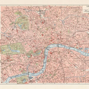
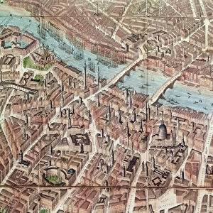
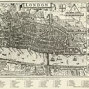
Photographic Print : Map / London / City Late 16C

![]()
Photo Prints from Mary Evans Picture Library
Map / London / City Late 16C
Plan of the City of London in the Time of Queen Elizabeth
Mary Evans Picture Library makes available wonderful images created for people to enjoy over the centuries
Media ID 4342725
© Mary Evans Picture Library 2015 - https://copyrighthub.org/s0/hub1/creation/maryevans/MaryEvansPictureID/10046439
11"x8.5" Photo Print
Discover history like never before with Media Storehouse's exquisite range of Photographic Prints. This particular piece showcases an intriguing map of London from the late 16th century, as seen in the "Map / London / City Late 16C" print from Mary Evans Prints Online. Rights Managed. Transport yourself back in time as you explore the labyrinthine streets and landmarks of Elizabethan London. Each print is meticulously produced to preserve the rich detail and authenticity of the original image, making it a stunning addition to your home or office. Order yours today and let the story of London unfold before your eyes.
Photo prints are produced on Kodak professional photo paper resulting in timeless and breath-taking prints which are also ideal for framing. The colors produced are rich and vivid, with accurate blacks and pristine whites, resulting in prints that are truly timeless and magnificent. Whether you're looking to display your prints in your home, office, or gallery, our range of photographic prints are sure to impress. Dimensions refers to the size of the paper in inches.
Our Photo Prints are in a large range of sizes and are printed on Archival Quality Paper for excellent colour reproduction and longevity. They are ideal for framing (our Framed Prints use these) at a reasonable cost. Alternatives include cheaper Poster Prints and higher quality Fine Art Paper, the choice of which is largely dependant on your budget.
Estimated Image Size (if not cropped) is 27.9cm x 17.9cm (11" x 7")
Estimated Product Size is 27.9cm x 21.6cm (11" x 8.5")
These are individually made so all sizes are approximate
Artwork printed orientated as per the preview above, with landscape (horizontal) orientation to match the source image.
FEATURES IN THESE COLLECTIONS
> Europe
> United Kingdom
> England
> London
> Boroughs
> City of London
> Europe
> United Kingdom
> England
> London
> Related Images
> Europe
> United Kingdom
> England
> Maps
> Europe
> United Kingdom
> England
> Posters
> Europe
> United Kingdom
> England
> Related Images
> Maps and Charts
> Early Maps
> Maps and Charts
> Related Images
EDITORS COMMENTS
This print captures a detailed map of London from the late 16th century, specifically during the reign of Queen Elizabeth I. The intricate plan showcases the layout of the city during this historical period, offering viewers a glimpse into what life was like in England's bustling capital over four centuries ago.
The map provides a fascinating insight into the general structure and architecture of London at that time, with its winding streets, grand buildings, and bustling markets. It is truly a window into history, allowing us to imagine what it would have been like to walk through the streets of this vibrant city during the Elizabethan era.
Queen Elizabeth I was known for her strong leadership and influence over England during this period, making her presence felt throughout every corner of London. This map serves as a reminder of her legacy and impact on both the city and the country as a whole.
As we study this historical document, we are transported back in time to an age filled with intrigue, discovery, and change. It is a testament to how far London has come since then while also honoring its rich heritage and storied past.
MADE IN THE USA
Safe Shipping with 30 Day Money Back Guarantee
FREE PERSONALISATION*
We are proud to offer a range of customisation features including Personalised Captions, Color Filters and Picture Zoom Tools
SECURE PAYMENTS
We happily accept a wide range of payment options so you can pay for the things you need in the way that is most convenient for you
* Options may vary by product and licensing agreement. Zoomed Pictures can be adjusted in the Cart.