Photographic Print > MapSeeker > British Town And City Plans > English & Welsh PORTFOLIO
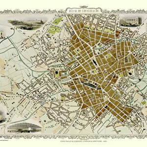
Photographic Print : Old Map of Birmingham 1883


![]()
Photo Prints From MapSeeker
Old Map of Birmingham 1883
==
Welcome to the Mapseeker Image library and enter an historic gateway to one of the largest on-line collections of Historic Maps, Nostalgic Views, Vista's and Panorama's from a World gone by.
Media ID 20347428
© reserved
Birmingham Birmingham City Birmingham City Map Birmingham Map Birmingham Town Plan City Of Birmingham Map Historic Birmingham Map Historic Map Map Of Birmingham Old Map Of Birmingham Old Town Plan Town Plan Of Birmingham
12"x8" Photo Print
Photo prints are produced on Kodak professional photo paper resulting in timeless and breath-taking prints which are also ideal for framing. The colors produced are rich and vivid, with accurate blacks and pristine whites, resulting in prints that are truly timeless and magnificent. Whether you're looking to display your prints in your home, office, or gallery, our range of photographic prints are sure to impress. Dimensions refers to the size of the paper in inches.
Our Photo Prints are in a large range of sizes and are printed on Archival Quality Paper for excellent colour reproduction and longevity. They are ideal for framing (our Framed Prints use these) at a reasonable cost. Alternatives include cheaper Poster Prints and higher quality Fine Art Paper, the choice of which is largely dependant on your budget.
Estimated Product Size is 30.5cm x 20.3cm (12" x 8")
These are individually made so all sizes are approximate
Artwork printed orientated as per the preview above, with landscape (horizontal) orientation to match the source image.
EDITORS COMMENTS
This print showcases an exquisite piece of history - the Old Map of Birmingham from 1883. Stepping back in time, this map offers a fascinating glimpse into the city's past, revealing its intricate layout and architectural wonders that have shaped Birmingham into what it is today. With meticulous detail, this town plan of Birmingham highlights the bustling streets, iconic landmarks, and vibrant neighborhoods that once thrived within its boundaries. Each stroke on this historic map tells a story of growth and progress as the city evolved over time. As we explore this snapshot from yesteryears, we are transported to an era where horse-drawn carriages traversed cobblestone roads and grand Victorian buildings adorned the skyline. The old charm emanating from every corner invites us to imagine life in Birmingham during its formative years. Whether you are a history enthusiast or simply captivated by maps, this vintage gem will undoubtedly be a cherished addition to your collection. Its timeless beauty serves as a reminder of how cities transform while preserving their unique heritage. Displaying the Old Map of Birmingham proudly in your home or office not only pays homage to the rich legacy of this remarkable city but also sparks conversations about its evolution throughout generations. This print captures more than just cartographic details; it encapsulates memories and stories waiting to be discovered by those with an appreciation for both artistry and history alike.
MADE IN THE USA
Safe Shipping with 30 Day Money Back Guarantee
FREE PERSONALISATION*
We are proud to offer a range of customisation features including Personalised Captions, Color Filters and Picture Zoom Tools
SECURE PAYMENTS
We happily accept a wide range of payment options so you can pay for the things you need in the way that is most convenient for you
* Options may vary by product and licensing agreement. Zoomed Pictures can be adjusted in the Basket.