Photographic Print > Maps and Charts > Germany
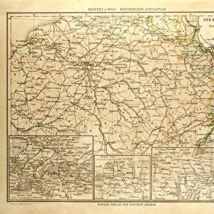
Photographic Print : Franco-Prussian War: Map of Alsace and Lorraine, Counties Given to the German Empire 1870

![]()
Photo Prints from Liszt Collection
Franco-Prussian War: Map of Alsace and Lorraine, Counties Given to the German Empire 1870
Liszt Collection of nineteenth-century engravings and images to browse and enjoy
Media ID 12825293
© Quint Lox Limited
Alsace Empire Franco Prussian War Lorraine Counties
11"x8.5" Photo Print
Step back in time with our exquisite reproduction of the Franco-Prussian War: Map of Alsace and Lorraine, Counties Given to the German Empire 1870, from the esteemed Liszt Collection. This captivating historical print, featuring the detailed cartography of the territorial changes during the Franco-Prussian War, is a must-have for history enthusiasts and collectors. The intricate lines and precise shading bring the map to life, transporting you to a bygone era. Display this beautiful piece in your home or office as a conversation starter or a reminder of the rich history that shaped our world. Order yours today and add a touch of historical charm to your space.
Photo prints are produced on Kodak professional photo paper resulting in timeless and breath-taking prints which are also ideal for framing. The colors produced are rich and vivid, with accurate blacks and pristine whites, resulting in prints that are truly timeless and magnificent. Whether you're looking to display your prints in your home, office, or gallery, our range of photographic prints are sure to impress. Dimensions refers to the size of the paper in inches.
Our Photo Prints are in a large range of sizes and are printed on Archival Quality Paper for excellent colour reproduction and longevity. They are ideal for framing (our Framed Prints use these) at a reasonable cost. Alternatives include cheaper Poster Prints and higher quality Fine Art Paper, the choice of which is largely dependant on your budget.
Estimated Image Size (if not cropped) is 18.7cm x 27.9cm (7.4" x 11")
Estimated Product Size is 21.6cm x 27.9cm (8.5" x 11")
These are individually made so all sizes are approximate
Artwork printed orientated as per the preview above, with portrait (vertical) orientation to match the source image.
FEATURES IN THESE COLLECTIONS
> Maps and Charts
> Related Images
EDITORS COMMENTS
This print showcases a historical map of Alsace and Lorraine, two counties that were given to the German Empire during the Franco-Prussian War in 1870. The intricate engravement technique used to create this image transports us back to the 19th century, immersing us in its Victorian charm. With its vintage and retro style, this piece of historic art from Arkheia evokes a sense of nostalgia for a bygone era. The map itself is meticulously detailed, highlighting the borders and topography of Alsace and Lorraine with precision. It serves as a visual representation of the territorial changes that occurred during one of Europe's most significant conflicts. As we gaze upon this engraving, we are reminded of the cultural impact such events had on nations involved. Through this print, we gain insight into not only the military aspects but also how history intertwines with arts and culture. Its presence reminds us that even in times marked by conflict, there is beauty to be found in illustrative techniques like engravings. As we reflect on this historical artifact from the Liszt Collection, it prompts us to contemplate how our world has evolved since those tumultuous times. This image serves as both an educational tool and a testament to human resilience throughout history.
MADE IN THE USA
Safe Shipping with 30 Day Money Back Guarantee
FREE PERSONALISATION*
We are proud to offer a range of customisation features including Personalised Captions, Color Filters and Picture Zoom Tools
SECURE PAYMENTS
We happily accept a wide range of payment options so you can pay for the things you need in the way that is most convenient for you
* Options may vary by product and licensing agreement. Zoomed Pictures can be adjusted in the Cart.