Photographic Print > Europe > Spain > Related Images
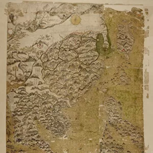
Photographic Print : MEXICO: TZINTZUNTZAN. Map of Tzintzuntzan, the Spanish colonial headquarters in the region

![]()
Photo Prints From Granger
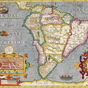
MEXICO: TZINTZUNTZAN. Map of Tzintzuntzan, the Spanish colonial headquarters in the region
MEXICO: TZINTZUNTZAN.
Map of Tzintzuntzan, the Spanish colonial headquarters in the region (center); the silver mining town of Patzcuaro (top); and other towns surrounding Lake Patzcuaro in Mexico, 18th century
Granger holds millions of images spanning more than 25,000 years of world history, from before the Stone Age to the dawn of the Space Age
Media ID 12415868
Bradley Smith Colonial Headquarters Lake Latin America Latin American Mesoamerica Mesoamerican Mexican Mexico Mine New Spain Silver Spanish Town Patzcuaro Topographic
10"x10" Photo Print
Discover the rich history of Mexico with our stunning photographic print from Media Storehouse, featuring a captivating map of Tzintzuntzan. This vintage illustration showcases the Spanish colonial headquarters in the region, surrounded by the picturesque towns of Patzcuaro and other charming settlements nestled around Lake Patzcuaro. Bring the beauty and culture of Mexico into your home or office with this unique and intriguing piece from Granger Art on Demand.
Photo prints are produced on Kodak professional photo paper resulting in timeless and breath-taking prints which are also ideal for framing. The colors produced are rich and vivid, with accurate blacks and pristine whites, resulting in prints that are truly timeless and magnificent. Whether you're looking to display your prints in your home, office, or gallery, our range of photographic prints are sure to impress. Dimensions refers to the size of the paper in inches.
Our Photo Prints are in a large range of sizes and are printed on Archival Quality Paper for excellent colour reproduction and longevity. They are ideal for framing (our Framed Prints use these) at a reasonable cost. Alternatives include cheaper Poster Prints and higher quality Fine Art Paper, the choice of which is largely dependant on your budget.
Estimated Image Size (if not cropped) is 25.4cm x 23cm (10" x 9.1")
Estimated Product Size is 25.4cm x 25.4cm (10" x 10")
These are individually made so all sizes are approximate
Artwork printed orientated as per the preview above, with landscape (horizontal) orientation to match the source image.
EDITORS COMMENTS
This 18th-century print showcases a detailed map of Tzintzuntzan, the Spanish colonial headquarters in Mexico. Created by Bradley Smith, this piece from the Carousel Collection takes us back to a time when bustling cities and silver mines shaped the landscape of Latin America. The center of attention on this map is undoubtedly Tzintzuntzan itself, with its intricate streets and grand buildings that reflect the influence of Spanish architecture. As we move our gaze upwards, we encounter Patzcuaro, a thriving silver mining town nestled near Lake Patzcuaro. The topographic details beautifully capture the natural beauty surrounding these urban centers. Mesoamerica comes alive through this artwork as it transports us to New Spain during its colonial era. The fusion between indigenous culture and European colonization is evident in every stroke of this drawing. It serves as a testament to the rich history and heritage that shaped modern-day Mexico. Bradley Smith's meticulous craftsmanship allows us to explore not only geographical features but also historical narratives embedded within each town represented on this map. This print offers an opportunity for viewers to delve into Mexican history while appreciating the artistic talent behind it.
MADE IN THE USA
Safe Shipping with 30 Day Money Back Guarantee
FREE PERSONALISATION*
We are proud to offer a range of customisation features including Personalised Captions, Color Filters and Picture Zoom Tools
SECURE PAYMENTS
We happily accept a wide range of payment options so you can pay for the things you need in the way that is most convenient for you
* Options may vary by product and licensing agreement. Zoomed Pictures can be adjusted in the Basket.