Photographic Print > Arts > Artists > R > Roman Roman
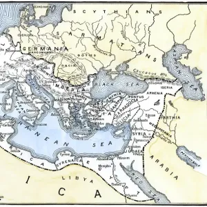
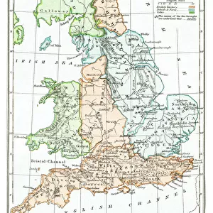
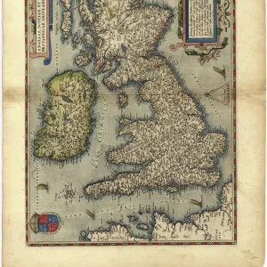
Photographic Print : Antique map of Britain under the Ancient Romans


![]()
Photo Prints from Fine Art Storehouse
Antique map of Britain under the Ancient Romans
Unleash your creativity and transform your space into a visual masterpiece!
duncan1890
Media ID 14549473
© This content is subject to copyright
10"x8" Photo Print
Discover the rich history of Ancient Rome in Britain with this stunning antique map print from the Media Storehouse Fine Art collection. Created by the talented artist duncan1890, this exquisite piece transports you back in time, depicting Britain as it was known during the Roman occupation. Add an air of sophistication and historical charm to your home or office with this beautifully detailed and intricately designed map print. The vibrant colors and meticulous attention to detail bring the past to life, making it a captivating conversation starter and a cherished addition to any space. Elevate your decor and indulge in the beauty of history with this exceptional antique map print from Media Storehouse Fine Art.
Photo prints are produced on Kodak professional photo paper resulting in timeless and breath-taking prints which are also ideal for framing. The colors produced are rich and vivid, with accurate blacks and pristine whites, resulting in prints that are truly timeless and magnificent. Whether you're looking to display your prints in your home, office, or gallery, our range of photographic prints are sure to impress. Dimensions refers to the size of the paper in inches.
Our Photo Prints are in a large range of sizes and are printed on Archival Quality Paper for excellent colour reproduction and longevity. They are ideal for framing (our Framed Prints use these) at a reasonable cost. Alternatives include cheaper Poster Prints and higher quality Fine Art Paper, the choice of which is largely dependant on your budget.
Estimated Image Size (if not cropped) is 18cm x 25.4cm (7.1" x 10")
Estimated Product Size is 20.3cm x 25.4cm (8" x 10")
These are individually made so all sizes are approximate
Artwork printed orientated as per the preview above, with portrait (vertical) orientation to match the source image.
FEATURES IN THESE COLLECTIONS
> Fine Art Storehouse
> Map
> Historical Maps
> Fine Art Storehouse
> Top Sellers - Art Prints
> Arts
> Artists
> R
> Roman Roman
> Maps and Charts
> Early Maps
> Maps and Charts
> Related Images
EDITORS COMMENTS
In this print titled "Antique map of Britain under the Ancient Romans" we are transported back in time to an era of great historical significance. The intricate details and delicate craftsmanship of this antique map bring to life the ancient world as it once was, specifically focusing on the Roman occupation of Britain. As our eyes wander across the aged parchment, we can trace the contours of Britannia's landscape, dotted with cities, rivers, and roads that were crucial arteries connecting different corners of this vast empire. The map reveals how the Romans meticulously established their dominion over these lands, leaving a lasting imprint on British history. The artist behind this remarkable piece, Duncan1890 from Fine Art Storehouse, has masterfully captured every nuance and subtlety in his reproduction. Through careful preservation and restoration techniques employed by skilled artisans at Fine Art Storehouse, this print allows us to appreciate not only its aesthetic beauty but also its historical value. This antique map serves as a window into a distant past where empires clashed and cultures melded together. It invites us to ponder upon the lives lived during those times – soldiers marching along Hadrian's Wall or traders navigating treacherous seas around Britannia's shores. Whether you are an avid historian or simply captivated by artistry that transcends time itself, "Antique map of Britain under the Ancient Romans" is sure to ignite your imagination and transport you back centuries ago when Rome left an indelible mark on British soil.
MADE IN THE USA
Safe Shipping with 30 Day Money Back Guarantee
FREE PERSONALISATION*
We are proud to offer a range of customisation features including Personalised Captions, Color Filters and Picture Zoom Tools
SECURE PAYMENTS
We happily accept a wide range of payment options so you can pay for the things you need in the way that is most convenient for you
* Options may vary by product and licensing agreement. Zoomed Pictures can be adjusted in the Cart.