Photographic Print > North America > United States of America > New York > New York > Maps
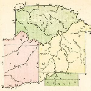
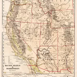
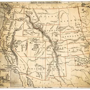
Photographic Print : USA Pacific States map of 1869


![]()
Photo Prints from Fine Art Storehouse
USA Pacific States map of 1869
Cornells Grammar School Geography By S.S. Cornell - New York 1869
Unleash your creativity and transform your space into a visual masterpiece!
THEPALMER
Media ID 18106825
© 2014 Roberto Adrian Photography
10"x8" Photo Print
Step back in time with our exquisite reproduction of the "USA Pacific States Map of 1869" from ThePalmer's collection at Fine Art Storehouse. Originally published in Cornell's Grammar School Geography by S.S. Cornell in New York, this vintage map offers a captivating glimpse into the history of the United States' western expansion. The intricate details and authentic colors bring the geography and cartography of the late 19th century to life, making this a perfect addition to any history enthusiast's collection or an elegant statement piece for your home or office decor. Order now and travel back in time with this stunning piece of historical cartography.
Photo prints are produced on Kodak professional photo paper resulting in timeless and breath-taking prints which are also ideal for framing. The colors produced are rich and vivid, with accurate blacks and pristine whites, resulting in prints that are truly timeless and magnificent. Whether you're looking to display your prints in your home, office, or gallery, our range of photographic prints are sure to impress. Dimensions refers to the size of the paper in inches.
Our Photo Prints are in a large range of sizes and are printed on Archival Quality Paper for excellent colour reproduction and longevity. They are ideal for framing (our Framed Prints use these) at a reasonable cost. Alternatives include cheaper Poster Prints and higher quality Fine Art Paper, the choice of which is largely dependant on your budget.
Estimated Product Size is 20.3cm x 25.4cm (8" x 10")
These are individually made so all sizes are approximate
Artwork printed orientated as per the preview above, with landscape (horizontal) or portrait (vertical) orientation to match the source image.
FEATURES IN THESE COLLECTIONS
> Fine Art Storehouse
> Map
> Historical Maps
> Fine Art Storehouse
> Map
> USA Maps
> Maps and Charts
> Related Images
> North America
> United States of America
> Maps
> North America
> United States of America
> New York
> New York
> Maps
> North America
> United States of America
> New York
> Related Images
EDITORS COMMENTS
In this print titled "USA Pacific States map of 1869" we are transported back in time to the era of exploration and discovery. The intricate details and historical significance captured in this piece make it a true gem for any history enthusiast or geography aficionado. The map, originally featured in Cornells Grammar School Geography By S. S. Cornell - New York 1869, showcases the vast expanse of the Pacific States during that period. With its meticulous cartography and vibrant colors, it offers a glimpse into the evolving landscape of America's western frontier. As we study this remarkable artifact, our imagination runs wild with thoughts of pioneers venturing into uncharted territories, seeking fortune and new beginnings. It serves as a visual reminder of the bravery and determination that shaped America's westward expansion. "ThePALMER" has skillfully captured every nuance of this vintage masterpiece through their lens, preserving its historical value for generations to come. This print from Fine Art Storehouse allows us to appreciate not only the artistry behind creating such maps but also their role in documenting our ever-changing world. Whether displayed proudly on a wall or used as an educational tool, this photograph invites us to explore our past while igniting curiosity about what lies beyond those borders today. It is a testament to human progress and serves as a timeless reminder that knowledge truly knows no bounds.
MADE IN THE USA
Safe Shipping with 30 Day Money Back Guarantee
FREE PERSONALISATION*
We are proud to offer a range of customisation features including Personalised Captions, Color Filters and Picture Zoom Tools
SECURE PAYMENTS
We happily accept a wide range of payment options so you can pay for the things you need in the way that is most convenient for you
* Options may vary by product and licensing agreement. Zoomed Pictures can be adjusted in the Cart.