Home > North America > United States of America > New York > New York > Maps
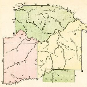
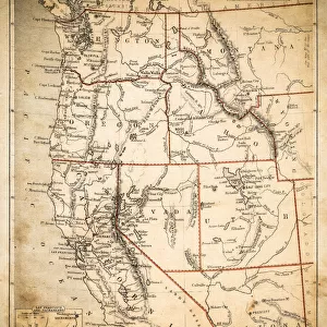
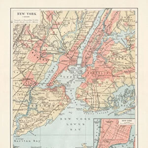
Middle states USA map 1869

![]()
Wall Art and Photo Gifts from Fine Art Storehouse
Middle states USA map 1869
Cornells Grammars-School Geography - S.S. Cornell - New York D. Appleton and Company 1869
Unleash your creativity and transform your space into a visual masterpiece!
THEPALMER
Media ID 13669019
© Roberto A Sanchez
Atlantic Ocean Background Backgrounds Delaware Us State Direction Grunge Grunge Image Technique Maryland Maryland State New Jersey New York City New York State North America Sepia Toned Obsolete
FEATURES IN THESE COLLECTIONS
> Fine Art Storehouse
> The Magical World of Illustration
> Palmer Illustrated Collection
> Fine Art Storehouse
> Map
> Historical Maps
> Fine Art Storehouse
> Map
> USA Maps
> Maps and Charts
> Early Maps
> Maps and Charts
> World
> North America
> United States of America
> Delaware
> Related Images
> North America
> United States of America
> Maps
> North America
> United States of America
> Maryland
> Related Images
> North America
> United States of America
> New Jersey
> Related Images
> North America
> United States of America
> New York
> New York
> Maps
EDITORS COMMENTS
This print takes us back in time to the year 1869, showcasing a vintage map of the Middle states of the USA. The map originates from "Cornells Grammars-School Geography" by S. S. Cornell, published by D. Appleton and Company in New York City. With its engraved image and sepia-toned background, this piece exudes an air of nostalgia. The intricate cartography on display highlights the physical geography of the region, featuring states such as New York, New Jersey, Maryland, and Delaware. The detailed engravings beautifully depict rivers, mountains, cities, and coastlines along the Atlantic Ocean. As we gaze at this old-world treasure through a grunge filter technique that adds character to the image itself, it's hard not to appreciate both its historical significance and artistic beauty. This vertical composition invites us to explore every corner with curiosity. Transporting us back over 150 years ago when this map was relevant for travelers and scholars alike; it serves as a reminder of how our understanding of geography has evolved over time. "The Middle States USA Map 1869" is more than just a decorative piece; it is an illustration that connects us with our past while reminding us how far we have come in terms of exploration and knowledge about our world.
MADE IN THE USA
Safe Shipping with 30 Day Money Back Guarantee
FREE PERSONALISATION*
We are proud to offer a range of customisation features including Personalised Captions, Color Filters and Picture Zoom Tools
SECURE PAYMENTS
We happily accept a wide range of payment options so you can pay for the things you need in the way that is most convenient for you
* Options may vary by product and licensing agreement. Zoomed Pictures can be adjusted in the Cart.