Metal Print > North America > United States of America > New York > New York > Maps
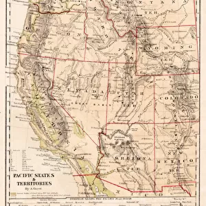
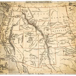
Metal Print : USA Pacific States map of 1869


![]()
Metal Prints from Fine Art Storehouse
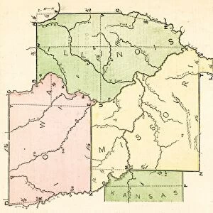
USA Pacific States map of 1869
Cornells Grammar School Geography By S.S. Cornell - New York 1869
Unleash your creativity and transform your space into a visual masterpiece!
THEPALMER
Media ID 18106825
© 2014 Roberto Adrian Photography
16"x20" (51x41cm) Metal Print
Discover history through the lens of time with our Media Storehouse Metal Print of the USA Pacific States Map from 1869 by THEPALMER. This exquisite piece is taken from the Cornells Grammar School Geography book published in New York in 1869. The intricate details of this vintage map are brought to life through our premium metal print process, ensuring vibrant colors and exceptional clarity. Add a touch of history and sophistication to your space with this unique and captivating piece.
Made with durable metal and luxurious printing techniques, our metal photo prints go beyond traditional canvases, adding a cool, modern touch to your space. Wall mount on back. Eco-friendly 100% post-consumer recycled ChromaLuxe aluminum surface. The thickness of the print is 0.045". Featuring a Scratch-resistant surface and Rounded corners. Backing hangers are attached to the back of the print and float the print 1/2-inch off the wall when hung, the choice of hanger may vary depending on size and International orders will come with Float Mount hangers only. Finished with a brilliant white high gloss surface for unsurpassed detail and vibrance. Printed using Dye-Sublimation and for best care we recommend a non-ammonia glass cleaner, water, or isopropyl (rubbing) alcohol to prevent harming the print surface. We recommend using a clean, lint-free cloth to wipe off the print. The ultra-hard surface is scratch-resistant, waterproof and weatherproof. Avoid direct sunlight exposure.
Made with durable metal and luxurious printing techniques, metal prints bring images to life and add a modern touch to any space
Estimated Image Size (if not cropped) is 40.6cm x 50.8cm (16" x 20")
Estimated Product Size is 41.2cm x 51.4cm (16.2" x 20.2")
These are individually made so all sizes are approximate
Artwork printed orientated as per the preview above, with portrait (vertical) orientation to match the source image.
FEATURES IN THESE COLLECTIONS
> Fine Art Storehouse
> Map
> Historical Maps
> Fine Art Storehouse
> Map
> USA Maps
> Maps and Charts
> Related Images
> North America
> United States of America
> Maps
> North America
> United States of America
> New York
> New York
> Maps
> North America
> United States of America
> New York
> Related Images
EDITORS COMMENTS
In this print titled "USA Pacific States map of 1869" we are transported back in time to the era of exploration and discovery. The intricate details and historical significance captured in this piece make it a true gem for any history enthusiast or geography aficionado. The map, originally featured in Cornells Grammar School Geography By S. S. Cornell - New York 1869, showcases the vast expanse of the Pacific States during that period. With its meticulous cartography and vibrant colors, it offers a glimpse into the evolving landscape of America's western frontier. As we study this remarkable artifact, our imagination runs wild with thoughts of pioneers venturing into uncharted territories, seeking fortune and new beginnings. It serves as a visual reminder of the bravery and determination that shaped America's westward expansion. "ThePALMER" has skillfully captured every nuance of this vintage masterpiece through their lens, preserving its historical value for generations to come. This print from Fine Art Storehouse allows us to appreciate not only the artistry behind creating such maps but also their role in documenting our ever-changing world. Whether displayed proudly on a wall or used as an educational tool, this photograph invites us to explore our past while igniting curiosity about what lies beyond those borders today. It is a testament to human progress and serves as a timeless reminder that knowledge truly knows no bounds.
MADE IN THE USA
Safe Shipping with 30 Day Money Back Guarantee
FREE PERSONALISATION*
We are proud to offer a range of customisation features including Personalised Captions, Color Filters and Picture Zoom Tools
SECURE PAYMENTS
We happily accept a wide range of payment options so you can pay for the things you need in the way that is most convenient for you
* Options may vary by product and licensing agreement. Zoomed Pictures can be adjusted in the Cart.