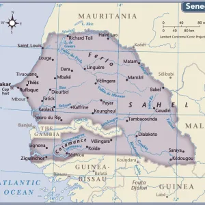
Photographic Print > Africa > The Gambia > Maps
Photographic Print : North Africa, Europe and the Middle East from the Catalan Atlas (reproduction)
")
![]()
Photo Prints from Fine Art Finder
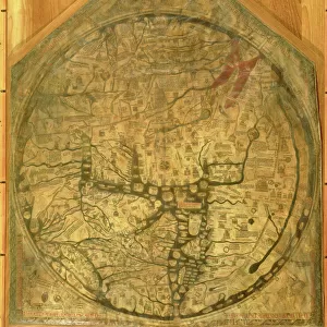
North Africa, Europe and the Middle East from the Catalan Atlas (reproduction)
5054659 North Africa, Europe and the Middle East from the Catalan Atlas (reproduction) by Cresques, Abraham (1325-87) (after); (add.info.: Detail from the reproduction of 1375 World map made in Majorca, attributed to the Jewish cartographer Abraham Cresques with Jerusalem close to the centre.
From the Atlantic to China, from Scandinavia to the Rio Oro in Africa. The King of Mali, " Musse Melly" (Mansa Musa) was known to control a large part of Africa, from Gambia and Senegal to Gao on the Niger, and had access to some of its richest gold deposits.); Spanish, out of copyright
Media ID 22597634
© Bridgeman Images
Atlas Camel Catalan Catalan Atlas Catalonia Compass Compass Lines Cosmography Early Map Elephant Hydrography Jerusalem Majorcan Mansa Musa Mappa Mundi Mediterranean Nautical Nautical Charts Navigation Navigational Portolan Red Sea Sea Chart Sicily Silk Road Spice Trade Spices Vellum World Map
11"x8.5" Photo Print
Discover the rich cultural tapestry of North Africa, Europe, and the Middle East through the captivating lens of the Catalan Atlas. This reproduction from Bridgeman Images, sourced from Fine Art Finder, brings to life the intricate detail and vibrant colors of this historic map. Originally created by Abraham Cresques in the 14th century, this iconic cartographic masterpiece transports you back in time, inviting you to explore the ancient civilizations and landmarks that shaped our world's history. Add this stunning piece to your collection and elevate your home or office decor with a touch of timeless beauty and historical significance.
Photo prints are produced on Kodak professional photo paper resulting in timeless and breath-taking prints which are also ideal for framing. The colors produced are rich and vivid, with accurate blacks and pristine whites, resulting in prints that are truly timeless and magnificent. Whether you're looking to display your prints in your home, office, or gallery, our range of photographic prints are sure to impress. Dimensions refers to the size of the paper in inches.
Our Photo Prints are in a large range of sizes and are printed on Archival Quality Paper for excellent colour reproduction and longevity. They are ideal for framing (our Framed Prints use these) at a reasonable cost. Alternatives include cheaper Poster Prints and higher quality Fine Art Paper, the choice of which is largely dependant on your budget.
Estimated Image Size (if not cropped) is 27.9cm x 18.6cm (11" x 7.3")
Estimated Product Size is 27.9cm x 21.6cm (11" x 8.5")
These are individually made so all sizes are approximate
Artwork printed orientated as per the preview above, with landscape (horizontal) orientation to match the source image.
FEATURES IN THESE COLLECTIONS
> Fine Art Finder
> Artists
> Abraham (after) Cresques
> Africa
> The Gambia
> Maps
> Africa
> Mali
> Related Images
> Africa
> Niger
> Related Images
> Africa
> Related Images
> Africa
> Senegal
> Related Images
> Animals
> Mammals
> African Elephant
EDITORS COMMENTS
This print showcases a detail from the reproduction of the Catalan Atlas, a 14th-century world map created by Abraham Cresques, a Jewish cartographer from Majorca. The image depicts North Africa, Europe, and the Middle East with Jerusalem positioned near the center. Spanning from Scandinavia to the Rio Oro in Africa and from the Atlantic to China, this intricate map offers a glimpse into medieval geographical knowledge. It highlights significant landmarks such as Sicily, Greece, Turkey, and even includes camel caravans traversing vast deserts. One notable figure mentioned is Mansa Musa, also known as "Musse Melly" who reigned as King of Mali during that time period. He controlled an extensive portion of Africa stretching from Gambia and Senegal to Gao on the Niger River while having access to abundant gold deposits. The Catalan Atlas not only served navigational purposes but also played a crucial role in facilitating trade routes for spices along the Silk Road. Its detailed depiction of coastlines and maritime information made it an invaluable tool for sailors exploring uncharted territories. Crafted on vellum using meticulous cartographic techniques prevalent during that era, this reproduction preserves both historical significance and artistic beauty. With its rich colors and precise compass lines guiding seafarers across oceans, this piece serves as a testament to human curiosity about our world's vastness centuries ago.
MADE IN THE USA
Safe Shipping with 30 Day Money Back Guarantee
FREE PERSONALISATION*
We are proud to offer a range of customisation features including Personalised Captions, Color Filters and Picture Zoom Tools
SECURE PAYMENTS
We happily accept a wide range of payment options so you can pay for the things you need in the way that is most convenient for you
* Options may vary by product and licensing agreement. Zoomed Pictures can be adjusted in the Cart.