Photo Mug > Europe > Spain > Related Images
Photo Mug : Spain. Catalonia. Barcelona. Map, 1576 at Civitates


![]()
Home Decor From Mary Evans Picture Library
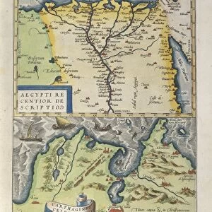
Spain. Catalonia. Barcelona. Map, 1576 at Civitates
Spain. Catalonia. Barcelona. Map, 1576 at Civitates Orbis Terrarum by Georg Braun (1541-1622) and Franz Hogenberg (1536-1590). Salamanca University Library
Mary Evans Picture Library makes available wonderful images created for people to enjoy over the centuries
Media ID 14404650
© Thaliastock / Mary Evans
1576 Agriculture Barcelona Cartography Catalan Catalonia Civitates Crop Farmer Hogenberg Mediterranean Orbis Plough Terrarum
Photo Mug (11 oz)
Bring a piece of Spain's rich history into your daily routine with our Media Storehouse Photo Mug featuring an intricately detailed map of Catalonia and Barcelona from the 1576 edition of "Civitates Orbis Terrarum" by Georg Braun and Franz Hogenberg. This stunning antique map, sourced from the Salamanca University Library and available through Mary Evans Prints Online, showcases the architectural wonders and geographical layout of the region during the Renaissance period. Each mug is expertly printed with high-quality, vibrant colors, ensuring your favorite beverage looks as good as the map itself. Perfect for history enthusiasts or as a thoughtful gift, this Photo Mug is a unique and captivating way to enjoy your morning coffee or tea.
A personalized photo mug blends sentimentality with functionality, making an ideal gift for cherished loved ones, close friends, or valued colleagues. Preview may show both sides of the same mug.
Elevate your coffee or tea experience with our premium white ceramic mug. Its wide, comfortable handle makes drinking easy, and you can rely on it to be both microwave and dishwasher safe. Sold in single units, preview may show both sides of the same mug so you can see how the picture wraps around.
Estimated Image Size (if not cropped) is 9.5cm x 7.4cm (3.7" x 2.9")
Mug Size is 8cm high x 9.5cm diameter (3.1" x 3.7")
These are individually made so all sizes are approximate
EDITORS COMMENTS
This map print, titled "Catalonia. Barcelona" from the atlas "Civitates Orbis Terrarum," was created by the renowned cartographers Georg Braun and Franz Hogenberg in 1576. The map provides a fascinating glimpse into the Mediterranean landscape of Catalonia, with a particular focus on the vibrant city of Barcelona during the late 16th century. The map is adorned with intricate details, showcasing the topography, cities, and towns of the region. The rolling hills and verdant fields are depicted in rich greens and browns, with the sparkling Mediterranean Sea in the foreground. The map reveals the extensive agricultural activities of the time, with farmers working the land and tending to their crops, which include grains, olives, and vineyards. The map also highlights the urban landscape of Barcelona, with its winding streets, fortifications, and prominent buildings. The Pla de Palau, the Gothic Quarter, and the harbor are all clearly visible, providing a snapshot of the city's layout and importance as a major port during the Modern Age. The map, which is part of the extensive collection at the Salamanca University Library, is a testament to the meticulous cartographic skills of Braun and Hogenberg during the Age of Discovery. The rich colors, intricate details, and historical significance make this map a valuable resource for scholars, historians, and anyone interested in the history of Catalonia and Barcelona during the 16th century.
MADE IN THE USA
Safe Shipping with 30 Day Money Back Guarantee
FREE PERSONALISATION*
We are proud to offer a range of customisation features including Personalised Captions, Color Filters and Picture Zoom Tools
SECURE PAYMENTS
We happily accept a wide range of payment options so you can pay for the things you need in the way that is most convenient for you
* Options may vary by product and licensing agreement. Zoomed Pictures can be adjusted in the Basket.