Home > North America > United States of America > California > Alameda
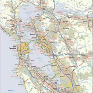
Graphic chart of the city and county of San Francisco respectfully dedicated to the leading interests of California and the Pacific coast. Lithograph after a drawing by Frederick Marriot, c1875

![]()
Wall Art and Photo Gifts from Granger
Graphic chart of the city and county of San Francisco respectfully dedicated to the leading interests of California and the Pacific coast. Lithograph after a drawing by Frederick Marriot, c1875
MAP: SAN FRANCISCO, c1875.
Graphic chart of the city and county of San Francisco respectfully dedicated to the leading interests of California and the Pacific coast. Lithograph after a drawing by Frederick Marriot, c1875
Granger holds millions of images spanning more than 25,000 years of world history, from before the Stone Age to the dawn of the Space Age
Media ID 10408008
1875 Birds Eye View California Chart Frederick Harbor Landmark San Francisco Ship United States Alameda Marriot Oakland
FEATURES IN THESE COLLECTIONS
> Granger Art on Demand
> Plans and Diagrams
> North America
> United States of America
> California
> Alameda
> North America
> United States of America
> California
> San Francisco
EDITORS COMMENTS
This lithograph, created by Frederick Marriot in 1875, offers a mesmerizing birds-eye view of the vibrant city and county of San Francisco. With its intricate details and meticulous craftsmanship, this graphic chart is a testament to Marriot's artistic talent and his dedication to capturing the essence of California and the Pacific coast. The lithograph showcases the bustling harbor with ships gracefully sailing through the bay, symbolizing the city's thriving maritime industry. The iconic landmarks such as Alameda, Oakland, Burlingame are meticulously depicted, giving viewers a sense of familiarity and pride for their beloved city. As you gaze upon this print, you can't help but be transported back in time to late 19th century America. The lithograph provides us with an invaluable glimpse into San Francisco's rich history and its pivotal role as one of United States' most influential cities. Granger Art on Demand has beautifully preserved this piece from their collection - a true treasure that encapsulates both artistry and historical significance. Whether you're an admirer of American history or simply captivated by stunning artwork, this lithograph is sure to leave a lasting impression.
MADE IN THE USA
Safe Shipping with 30 Day Money Back Guarantee
FREE PERSONALISATION*
We are proud to offer a range of customisation features including Personalised Captions, Color Filters and Picture Zoom Tools
SECURE PAYMENTS
We happily accept a wide range of payment options so you can pay for the things you need in the way that is most convenient for you
* Options may vary by product and licensing agreement. Zoomed Pictures can be adjusted in the Cart.