Jigsaw Puzzle > Europe > Spain > Related Images
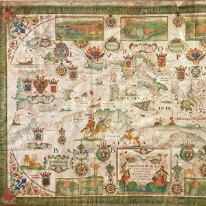
Jigsaw Puzzle : Spain. Catalonia. Barcelona. Map, 1576 at Civitates


![]()
Jigsaw Puzzles From Mary Evans Picture Library
Spain. Catalonia. Barcelona. Map, 1576 at Civitates
Spain. Catalonia. Barcelona. Map, 1576 at Civitates Orbis Terrarum by Georg Braun (1541-1622) and Franz Hogenberg (1536-1590). Salamanca University Library
Mary Evans Picture Library makes available wonderful images created for people to enjoy over the centuries
Media ID 14404650
© Thaliastock / Mary Evans
1576 Agriculture Barcelona Cartography Catalan Catalonia Civitates Crop Farmer Hogenberg Mediterranean Orbis Plough Terrarum
Jigsaw Puzzle (1014 Pieces)
Discover the rich history and culture of Catalonia, Spain with our captivating jigsaw puzzle from Media Storehouse. This intricately detailed puzzle features an antique map of Barcelona, dated 1576 from the renowned Civitates Orbis Terrarum collection. Originally created by Georg Braun and Franz Hogenberg, this map is now brought to life in puzzle form, allowing you to explore the intricate details of this historic city. Immerse yourself in the past as you piece together this beautiful and educational puzzle, perfect for history buffs, puzzle enthusiasts, or anyone looking for a challenging and rewarding pastime.
Made in the USA, 1014-piece puzzles measure 20" x 30" (50.8 x 76.2 cm). Every puzzle is meticulously printed on glossy photo paper, which has a strong 1.33 mm thickness. Delivered in a black storage cardboard box, these puzzles are both stylish and practical. (Note: puzzles contain small parts and are not suitable for children under 3 years of age.)
Jigsaw Puzzles are an ideal gift for any occasion
Estimated Product Size is 76cm x 50.8cm (29.9" x 20")
These are individually made so all sizes are approximate
Artwork printed orientated as per the preview above, with landscape (horizontal) orientation to match the source image.
EDITORS COMMENTS
This map print, titled "Catalonia. Barcelona" from the atlas "Civitates Orbis Terrarum," was created by the renowned cartographers Georg Braun and Franz Hogenberg in 1576. The map provides a fascinating glimpse into the Mediterranean landscape of Catalonia, with a particular focus on the vibrant city of Barcelona during the late 16th century. The map is adorned with intricate details, showcasing the topography, cities, and towns of the region. The rolling hills and verdant fields are depicted in rich greens and browns, with the sparkling Mediterranean Sea in the foreground. The map reveals the extensive agricultural activities of the time, with farmers working the land and tending to their crops, which include grains, olives, and vineyards. The map also highlights the urban landscape of Barcelona, with its winding streets, fortifications, and prominent buildings. The Pla de Palau, the Gothic Quarter, and the harbor are all clearly visible, providing a snapshot of the city's layout and importance as a major port during the Modern Age. The map, which is part of the extensive collection at the Salamanca University Library, is a testament to the meticulous cartographic skills of Braun and Hogenberg during the Age of Discovery. The rich colors, intricate details, and historical significance make this map a valuable resource for scholars, historians, and anyone interested in the history of Catalonia and Barcelona during the 16th century.
MADE IN THE USA
Safe Shipping with 30 Day Money Back Guarantee
FREE PERSONALISATION*
We are proud to offer a range of customisation features including Personalised Captions, Color Filters and Picture Zoom Tools
SECURE PAYMENTS
We happily accept a wide range of payment options so you can pay for the things you need in the way that is most convenient for you
* Options may vary by product and licensing agreement. Zoomed Pictures can be adjusted in the Basket.