Photo Mug > Europe > France > Paris > Maps
Photo Mug : Map / Paris 18C


![]()
Home Decor from Mary Evans Picture Library
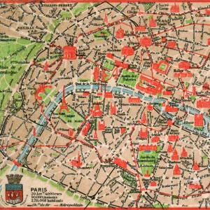
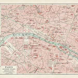
Map / Paris 18C
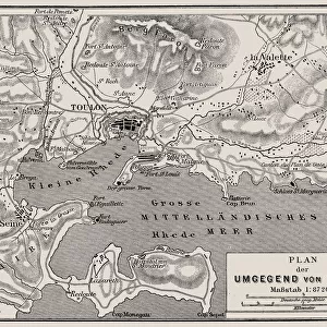
Detailed map of Paris, showing the many churches
Mary Evans Picture Library makes available wonderful images created for people to enjoy over the centuries
Media ID 602673
© Mary Evans Picture Library 2015 - https://copyrighthub.org/s0/hub1/creation/maryevans/MaryEvansPictureID/10123040
Large Photo Mug (15 oz)
Introducing the Media Storehouse Photo Mug, a perfect blend of functionality and style. Featuring an exquisite image from Mary Evans Picture Library, this mug showcases "Map / Paris 18C," a detailed and captivating map of the City of Love during the 1800s. Each mug in our range is meticulously printed with high-quality images, ensuring vibrant and long-lasting colors that bring your favorite maps, art, or photographs to life. The large, clear viewing area lets you enjoy the intricate details of this beautiful map of Paris, adorned with numerous churches and historic sites. Whether you're sipping your morning coffee or enjoying a warm beverage during a relaxing evening, the Media Storehouse Photo Mug adds a touch of elegance and personality to your daily routine. So why not treat yourself or someone special to a unique and practical gift that's sure to be treasured for years to come?
Elevate your coffee or tea experience with our premium white ceramic mug. Its wide, comfortable handle makes drinking easy, and you can rely on it to be both microwave and dishwasher safe. Sold in single units, preview may show both sides of the same mug so you can see how the picture wraps around.
Elevate your coffee or tea experience with our premium white ceramic mug. Its wide, comfortable handle makes drinking easy, and you can rely on it to be both microwave and dishwasher safe. Sold in single units, preview may show both sides of the same mug so you can see how the picture wraps around.
These are individually made so all sizes are approximate
FEATURES IN THESE COLLECTIONS
> Arts
> Photorealistic artworks
> Detailed art pieces
> Masterful detailing in art
> Europe
> France
> Paris
> Maps
> Europe
> France
> Paris
> Related Images
> Europe
> Related Images
> Maps and Charts
> Early Maps
> Maps and Charts
> Related Images
EDITORS COMMENTS
This stunning print captures a detailed map of Paris from the 18th century, showcasing the many churches that dotted the cityscape during this historical period. The intricate design and wealth of information displayed on this map offer a fascinating glimpse into the past, allowing viewers to explore Paris as it was centuries ago.
Each church is meticulously labeled, providing insight into the religious landscape of Paris in the 18th century. From grand cathedrals to small chapels, these buildings were not only places of worship but also important landmarks that shaped the city's identity.
The map itself is a work of art, with intricate illustrations and elegant typography adding to its charm. It serves as a reminder of France's rich history and cultural heritage, offering a window into life in Europe during this time period.
Whether you are a history buff, an art enthusiast, or simply someone who appreciates beautiful design, this print is sure to captivate your imagination. Display it in your home or office to add a touch of old-world charm and sophistication to any space. Mary Evans Picture Library has truly captured the essence of Paris in the 18th century with this remarkable piece.
MADE IN THE USA
Safe Shipping with 30 Day Money Back Guarantee
FREE PERSONALISATION*
We are proud to offer a range of customisation features including Personalised Captions, Color Filters and Picture Zoom Tools
SECURE PAYMENTS
We happily accept a wide range of payment options so you can pay for the things you need in the way that is most convenient for you
* Options may vary by product and licensing agreement. Zoomed Pictures can be adjusted in the Cart.