Home > Europe > France > Canton > Loire
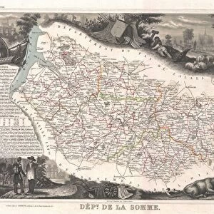
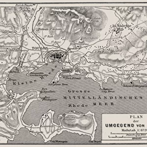
1847, Levasseur Map of Dept. Maine et Loire, France, topography, cartography, geography

![]()
Wall Art and Photo Gifts from Liszt Collection
1847, Levasseur Map of Dept. Maine et Loire, France, topography, cartography, geography
1847, Levasseur Map of Dept. Maine et Loire, France
Liszt Collection of nineteenth-century engravings and images to browse and enjoy
Media ID 14005129
© Artokoloro Quint Lox Limited
1847 Antique Map Atlas Chart Geographic Latitude Longitude Mappa Mundi Old Antique Plan Old Antique View Old Map Ols Antique Map Rare Old Maps Topo
FEATURES IN THESE COLLECTIONS
> Europe
> France
> Canton
> Loire
> Europe
> France
> Canton
> Maine
> Maps and Charts
> Early Maps
> Maps and Charts
> World
EDITORS COMMENTS
This print showcases the remarkable 1847 Levasseur Map of Dept. Maine et Loire, France. A true masterpiece in cartography, this map beautifully depicts the topography and geography of the region with intricate detail and precision. Its vintage charm takes us back to a bygone era when maps were meticulously hand-drawn works of art. The Levasseur Map not only serves as a navigational tool but also offers a glimpse into the rich history and heritage of this French department. Its aged appearance adds an air of authenticity, making it an invaluable resource for historians, researchers, or anyone fascinated by old-world charm. With its decorative elements and artistic flair, this map is more than just a geographical representation; it is an invitation to embark on a journey through time and space. As we explore each latitude and longitude line on its grid-like surface, we are transported to an era where discovery and exploration were at their peak. As we admire this rare antique map from the Liszt Collection, we can't help but marvel at how far our understanding of the world has come since 1847. It reminds us that even in today's digital age, there is still something magical about holding a piece of history in our hands – a tangible connection to those who came before us.
MADE IN THE USA
Safe Shipping with 30 Day Money Back Guarantee
FREE PERSONALISATION*
We are proud to offer a range of customisation features including Personalised Captions, Color Filters and Picture Zoom Tools
SECURE PAYMENTS
We happily accept a wide range of payment options so you can pay for the things you need in the way that is most convenient for you
* Options may vary by product and licensing agreement. Zoomed Pictures can be adjusted in the Cart.