Canvas Print > Europe > France > Paris > Maps
Canvas Print : Map / Paris 18C


![]()
Canvas Prints from Mary Evans Picture Library
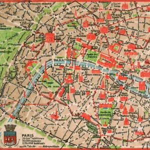
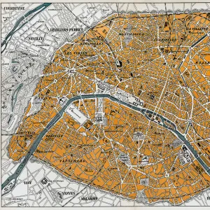
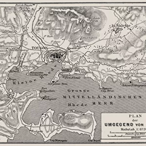
Map / Paris 18C
Detailed map of Paris, showing the many churches
Mary Evans Picture Library makes available wonderful images created for people to enjoy over the centuries
Media ID 602673
© Mary Evans Picture Library 2015 - https://copyrighthub.org/s0/hub1/creation/maryevans/MaryEvansPictureID/10123040
20"x16" (51x41cm) Canvas Print
Introducing the exquisite "Map / Paris 18C" Canvas Print from the Media Storehouse collection, brought to you in collaboration with Mary Evans Picture Library from Mary Evans Prints Online. This captivating piece transports you back in time to the 18th century, as you delve into the intricate details of this beautifully preserved map of Paris. Marvel at the many churches and architectural wonders that adorn the cityscape, each one meticulously depicted in this detailed and evocative representation of Paris during the 18th century. The rich, textured canvas adds depth and depth to the map, bringing history to life in your home or office. A perfect addition to any space, this Canvas Print not only serves as a stunning decorative piece but also as a conversation starter and an educational tool for those interested in history and urban planning. Embrace the past and bring a piece of Parisian history into your world with the Media Storehouse "Map / Paris 18C" Canvas Print.
Delivered stretched and ready to hang our premium quality canvas prints are made from a polyester/cotton blend canvas and stretched over a 1.25" (32mm) kiln dried knot free wood stretcher bar. Packaged in a plastic bag and secured to a cardboard insert for safe transit.
Canvas Prints add colour, depth and texture to any space. Professionally Stretched Canvas over a hidden Wooden Box Frame and Ready to Hang
Estimated Product Size is 50.8cm x 40.6cm (20" x 16")
These are individually made so all sizes are approximate
Artwork printed orientated as per the preview above, with landscape (horizontal) orientation to match the source image.
FEATURES IN THESE COLLECTIONS
> Arts
> Photorealistic artworks
> Detailed art pieces
> Masterful detailing in art
> Europe
> France
> Paris
> Maps
> Europe
> France
> Paris
> Related Images
> Europe
> Related Images
> Maps and Charts
> Early Maps
> Maps and Charts
> Related Images
EDITORS COMMENTS
This stunning print captures a detailed map of Paris from the 18th century, showcasing the many churches that dotted the cityscape during this historical period. The intricate design and wealth of information displayed on this map offer a fascinating glimpse into the past, allowing viewers to explore Paris as it was centuries ago.
Each church is meticulously labeled, providing insight into the religious landscape of Paris in the 18th century. From grand cathedrals to small chapels, these buildings were not only places of worship but also important landmarks that shaped the city's identity.
The map itself is a work of art, with intricate illustrations and elegant typography adding to its charm. It serves as a reminder of France's rich history and cultural heritage, offering a window into life in Europe during this time period.
Whether you are a history buff, an art enthusiast, or simply someone who appreciates beautiful design, this print is sure to captivate your imagination. Display it in your home or office to add a touch of old-world charm and sophistication to any space. Mary Evans Picture Library has truly captured the essence of Paris in the 18th century with this remarkable piece.
MADE IN THE USA
Safe Shipping with 30 Day Money Back Guarantee
FREE PERSONALISATION*
We are proud to offer a range of customisation features including Personalised Captions, Color Filters and Picture Zoom Tools
SECURE PAYMENTS
We happily accept a wide range of payment options so you can pay for the things you need in the way that is most convenient for you
* Options may vary by product and licensing agreement. Zoomed Pictures can be adjusted in the Cart.