Photo Mug > Maps and Charts > Africa
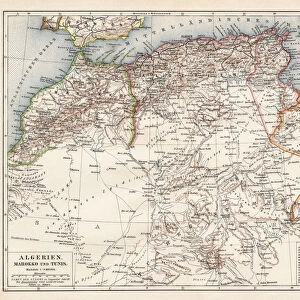
Photo Mug : Map of North east Africa 1896


![]()
Home Decor From Fine Art Storehouse
Map of North east Africa 1896
Andres Allgemeiner Handatlas - Bielefeld und Leipzig 1896
Unleash your creativity and transform your space into a visual masterpiece!
THEPALMER
Media ID 18356893
Large Photo Mug (15 oz)
Add a touch of history to your daily routine with our Media Storehouse Photo Mug featuring the captivating "Map of North East Africa 1896" by THEPALMER from Fine Art Storehouse. This exquisite map, taken from Andres Allgemeiner Handatlas published in Bielefeld and Leipzig in 1896, is now transformed into a functional and stylish mug. Perfect for tea or coffee, this mug not only keeps your beverage warm but also showcases your appreciation for historical cartography. Impress your guests with this unique and thoughtful gift or treat yourself to a piece of history that fits comfortably in your hands. Each mug is printed with high-quality, fade-resistant technology to ensure your map stays vibrant and clear, making every sip an adventure. Embrace the past, one mug at a time.
Elevate your coffee or tea experience with our premium white ceramic mug. Its wide, comfortable handle makes drinking easy, and you can rely on it to be both microwave and dishwasher safe. Sold in single units, preview may show both sides of the same mug so you can see how the picture wraps around.
Elevate your coffee or tea experience with our premium white ceramic mug. Its wide, comfortable handle makes drinking easy, and you can rely on it to be both microwave and dishwasher safe. Sold in single units, preview may show both sides of the same mug so you can see how the picture wraps around.
These are individually made so all sizes are approximate
FEATURES IN THESE COLLECTIONS
> Fine Art Storehouse
> Map
> Historical Maps
> Maps and Charts
> Related Images
EDITORS COMMENTS
This print showcases a historical gem, the "Map of North east Africa 1896" sourced from Andres Allgemeiner Handatlas - Bielefeld und Leipzig 1896. With its intricate details and vintage charm, this piece takes us back to a time when cartography was an art form in itself. The map offers a fascinating glimpse into the past, revealing the political boundaries and geographical features of Northeast Africa as they stood over a century ago. Delicately drawn lines trace the borders of countries that have since undergone significant changes, evoking curiosity about how history has shaped this region. The craftsmanship exhibited in this print is truly remarkable. Every contour and landmark is meticulously depicted, showcasing the dedication and precision required to create such an accurate representation of the land. The faded hues lend an air of nostalgia to the artwork, transporting viewers to a bygone era where exploration and discovery were at their peak. "The Map of North east Africa 1896" serves as both an educational tool for geography enthusiasts and a testament to human ingenuity in capturing our world on paper. It reminds us that maps are not just functional tools but also works of art that can inspire wonderment and spark imagination. Whether displayed in classrooms or homes, this print by THEPALMER from Fine Art Storehouse adds character and depth to any space while offering glimpses into our rich global heritage.
MADE IN THE USA
Safe Shipping with 30 Day Money Back Guarantee
FREE PERSONALISATION*
We are proud to offer a range of customisation features including Personalised Captions, Color Filters and Picture Zoom Tools
SECURE PAYMENTS
We happily accept a wide range of payment options so you can pay for the things you need in the way that is most convenient for you
* Options may vary by product and licensing agreement. Zoomed Pictures can be adjusted in the Basket.