Premium Framed Print > Maps and Charts > Africa
Premium Framed Print : Map of North east Africa 1896


![]()
Framed Photos From Fine Art Storehouse
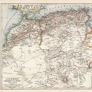
Map of North east Africa 1896
Andres Allgemeiner Handatlas - Bielefeld und Leipzig 1896
Unleash your creativity and transform your space into a visual masterpiece!
THEPALMER
Media ID 18356893
14"x16" Premium Frame
Contemporary style Premium Wooden Frame with 8"x10" Print. Complete with 2" White Mat and 1.25" thick MDF frame. Printed on 260 gsm premium paper. Glazed with shatter proof UV coated acrylic glass. Backing is paper covered backing with rubber bumpers. Supplied ready to hang with a pre-installed sawtooth/wire hanger. Care Instructions: Spot clean with a damp cloth. Securely packaged in a clear plastic bag and envelope in a reinforced cardboard shipper
FSC Real Wood Frame and Double Mounted with White Conservation Mountboard - Professionally Made and Ready to Hang
Estimated Image Size (if not cropped) is 20.3cm x 25.4cm (8" x 10")
Estimated Product Size is 35.6cm x 40.6cm (14" x 16")
These are individually made so all sizes are approximate
Artwork printed orientated as per the preview above, with portrait (vertical) orientation to match the source image.
FEATURES IN THESE COLLECTIONS
> Fine Art Storehouse
> Map
> Historical Maps
> Maps and Charts
> Related Images
EDITORS COMMENTS
This print showcases a historical gem, the "Map of North east Africa 1896" sourced from Andres Allgemeiner Handatlas - Bielefeld und Leipzig 1896. With its intricate details and vintage charm, this piece takes us back to a time when cartography was an art form in itself. The map offers a fascinating glimpse into the past, revealing the political boundaries and geographical features of Northeast Africa as they stood over a century ago. Delicately drawn lines trace the borders of countries that have since undergone significant changes, evoking curiosity about how history has shaped this region. The craftsmanship exhibited in this print is truly remarkable. Every contour and landmark is meticulously depicted, showcasing the dedication and precision required to create such an accurate representation of the land. The faded hues lend an air of nostalgia to the artwork, transporting viewers to a bygone era where exploration and discovery were at their peak. "The Map of North east Africa 1896" serves as both an educational tool for geography enthusiasts and a testament to human ingenuity in capturing our world on paper. It reminds us that maps are not just functional tools but also works of art that can inspire wonderment and spark imagination. Whether displayed in classrooms or homes, this print by THEPALMER from Fine Art Storehouse adds character and depth to any space while offering glimpses into our rich global heritage.
MADE IN THE USA
Safe Shipping with 30 Day Money Back Guarantee
FREE PERSONALISATION*
We are proud to offer a range of customisation features including Personalised Captions, Color Filters and Picture Zoom Tools
SECURE PAYMENTS
We happily accept a wide range of payment options so you can pay for the things you need in the way that is most convenient for you
* Options may vary by product and licensing agreement. Zoomed Pictures can be adjusted in the Basket.