Photo Mug > Fine Art Finder > Artists > Abraham (after) Cresques
Photo Mug : Copy of Catalan Map of Europe, North Africa and the Middle East (hand-coloured engraving)
")
")
![]()
Home Decor from Fine Art Finder
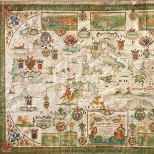
Copy of Catalan Map of Europe, North Africa and the Middle East (hand-coloured engraving)
XCF307352 Copy of Catalan Map of Europe, North Africa and the Middle East (hand-coloured engraving) by Cresques, Abraham (1325-87) (after); Private Collection; French, out of copyright
Media ID 12842014
© www.bridgemanart.com
Chart Cities Elephant Geographical Mapping Mediterranean Nautical Navigation Navigational Portolan Rhumb Lines
Large Photo Mug (15 oz)
Add a touch of history to your daily routine with our Media Storehouse Photo Mugs. Featuring an exquisite hand-coloured engraving of the Catalan Map of Europe, North Africa, and the Middle East by Abraham Cresques from the year 1325. This intricately detailed copy, sourced from Bridgeman Art and out of copyright, transports you back in time as you enjoy your favourite beverage. Each mug is expertly printed with high-quality, vibrant colours to bring the map to life, making it a unique and thoughtful gift for history enthusiasts or anyone who appreciates the beauty of fine art.
Elevate your coffee or tea experience with our premium white ceramic mug. Its wide, comfortable handle makes drinking easy, and you can rely on it to be both microwave and dishwasher safe. Sold in single units, preview may show both sides of the same mug so you can see how the picture wraps around.
Elevate your coffee or tea experience with our premium white ceramic mug. Its wide, comfortable handle makes drinking easy, and you can rely on it to be both microwave and dishwasher safe. Sold in single units, preview may show both sides of the same mug so you can see how the picture wraps around.
These are individually made so all sizes are approximate
EDITORS COMMENTS
This hand-coloured engraving, a copy of the Catalan Map of Europe, North Africa and the Middle East by Abraham Cresques, takes us on a journey back in time. With its intricate details and vibrant hues, this medieval map offers a window into the world of exploration and navigation. The map is adorned with rhumb lines that crisscross the page, guiding sailors through uncharted waters. It showcases numerous cities and towns along rivers, giving us glimpses into bustling medieval life. The presence of kings symbolizes their authority over vast territories while an elephant signifies exotic lands yet to be discovered. Geography enthusiasts will appreciate how this chart beautifully captures the coastal regions surrounding the Mediterranean Sea. Its nautical theme makes it an invaluable tool for seafarers seeking safe passage during treacherous voyages. As we gaze upon this historic piece, we are reminded of the importance placed on mapping during this era. Explorers relied heavily on such charts to navigate unknown territories and expand their knowledge of distant lands. Preserved in a private collection and now available as a print from Fine Art Finder, this remarkable artwork invites us to immerse ourselves in centuries past – where curiosity fueled discovery and cartography was both science and art.
MADE IN THE USA
Safe Shipping with 30 Day Money Back Guarantee
FREE PERSONALISATION*
We are proud to offer a range of customisation features including Personalised Captions, Color Filters and Picture Zoom Tools
SECURE PAYMENTS
We happily accept a wide range of payment options so you can pay for the things you need in the way that is most convenient for you
* Options may vary by product and licensing agreement. Zoomed Pictures can be adjusted in the Cart.