Home > Arts > Landscape paintings > Waterfall and river artworks > River artworks
EXPL2A-00026

![]()
Wall Art and Photo Gifts from North Wind
EXPL2A-00026
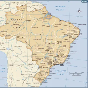
Map of South America, from Sebastian Cabots map of the world, 1544.
Hand colored 19th-century woodcut reproduction of the original map
North Wind Picture Archives brings history to life with stock images and hand-colored illustrations
Media ID 5880429
© North Wind Picture Archives
1500s 16th Century Amazon Andes Brazil Cape Horn Chart Discover Document Exploration Explore Inca Indian Latin America Mountains Native Navigation New World Patagonia Peru River Sailing Ship Ship South America 1540s 1544 Cabot Sebastian Cabot
FEATURES IN THESE COLLECTIONS
> Arts
> Landscape paintings
> Waterfall and river artworks
> River artworks
> Maps and Charts
> World
> North Wind Picture Archives
> Exploration
> North Wind Picture Archives
> Latin America:Caribbean
> North Wind Picture Archives
> Maps
> South America
> Brazil
> Maps
> South America
> Peru
> Maps
EDITORS COMMENTS
This print showcases a remarkable piece of history, the "EXPL2A-00026 Map of South America" derived from Sebastian Cabot's world map dating back to 1544. Hand-colored in the 19th century, this woodcut reproduction brilliantly captures the essence of the original map. Transporting us to an era of exploration and adventure, this vintage artwork takes us on a visual journey through time. It depicts Brazil, Peru, and Patagonia with intricate details that bring forth their rich cultural heritage. The illustration features indigenous people - Inca Indians - alongside a majestic sailing ship navigating through uncharted waters. The significance of this document lies not only in its historical value but also in its contribution to our understanding of Latin American geography during the 16th century. From the mighty Amazon River snaking through dense forests to towering mountains forming part of the Andes range, every element on this chart tells a story waiting to be discovered. Sebastian Cabot's map serves as a testament to human curiosity and ambition for exploration during an age when much of the New World remained unknown. It evokes feelings of awe and wonder as we imagine sailors braving treacherous seas around Cape Horn while seeking new lands beyond. As we gaze upon this artful representation, let it remind us that even centuries later, there is still so much left for us to explore both within ourselves and across vast landscapes like South America – where history intertwines with nature's magnificence.
MADE IN THE USA
Safe Shipping with 30 Day Money Back Guarantee
FREE PERSONALISATION*
We are proud to offer a range of customisation features including Personalised Captions, Color Filters and Picture Zoom Tools
SECURE PAYMENTS
We happily accept a wide range of payment options so you can pay for the things you need in the way that is most convenient for you
* Options may vary by product and licensing agreement. Zoomed Pictures can be adjusted in the Cart.