Home > North America > Canada > Maps
EXPL2A-00041

![]()
Wall Art and Photo Gifts from North Wind
EXPL2A-00041
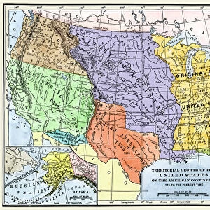
Map of territorial growth of the United States from 1783-1867.
Printed color lithograph of a 19th-century illustration
North Wind Picture Archives brings history to life with stock images and hand-colored illustrations
Media ID 5877456
© North Wind Picture Archives
1700s 1783 18th Century British California Canada Colonial Colony English Expansion French French Canada Frontier Land Claim Louisiana Louisiana Purchase Louisiana Territory Mexican New Spain North West Northwest Territory Old Northwest Oregon Oregon Territory Pacific Northwest Spanish Territory Texas
FEATURES IN THESE COLLECTIONS
> Maps and Charts
> Spain
> North America
> Canada
> Maps
> North Wind Picture Archives
> American history
EDITORS COMMENTS
This photo print, titled "EXPL2A-00041" showcases a remarkable map depicting the territorial growth of the United States from 1783 to 1867. With its vibrant printed color lithograph and intricate details, this vintage illustration takes us back to the 19th century, offering a glimpse into America's expansionist history. The map encompasses various significant regions that played pivotal roles in shaping the nation we know today. From California and Texas to Oregon and Louisiana, it vividly portrays the colonial territories acquired by different European powers such as English, Spanish, French, and even British Canada. As we explore this historic frontier through artistry and cartography combined, one cannot help but marvel at how these land claims transformed over time. The Louisiana Purchase of 1803 stands out prominently on this map as a turning point in American history when vast swaths of territory were acquired from France. Additionally, other notable acquisitions like the Gadsden Purchase further expanded U. S. borders towards Mexico. This visual representation serves as a valuable educational tool for understanding North America's complex geopolitical landscape during the late 18th and early 19th centuries. It allows us to appreciate how diverse influences shaped our continent into what it is today – an amalgamation of cultures with shared histories. With its historical significance and artistic charm, this print from North Wind Picture Archives offers viewers an opportunity to delve into America's past while appreciating both its beauty and complexity.
MADE IN THE USA
Safe Shipping with 30 Day Money Back Guarantee
FREE PERSONALISATION*
We are proud to offer a range of customisation features including Personalised Captions, Color Filters and Picture Zoom Tools
SECURE PAYMENTS
We happily accept a wide range of payment options so you can pay for the things you need in the way that is most convenient for you
* Options may vary by product and licensing agreement. Zoomed Pictures can be adjusted in the Cart.