Mouse Mat > Europe > United Kingdom > England > London > Towns > Paddington
Mouse Mat : Map of St Marylebone, London


![]()
Home Decor from Mary Evans Picture Library
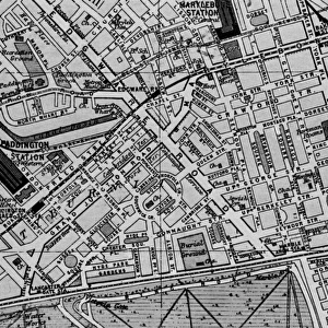
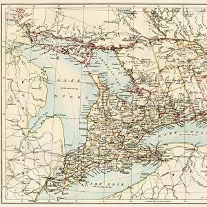
Map of St Marylebone, London
Map of St Marylebone, from a plan of London published by Richard Phillips. Date: 1813
Mary Evans Picture Library makes available wonderful images created for people to enjoy over the centuries
Media ID 14262926
© Mary Evans / Pharcide
1810s 1813 Area Cricket Edgware Georgian Lords Maps Marylebone Oxford Paddington Phillips Plan Soho Tottenham
Mouse Pad
Standard Size Mouse Pad 7.75" x 9..25". High density Neoprene w linen surface. Easy to clean, stain resistant finish. Rounded corners.
Archive quality photographic print in a durable wipe clean mouse mat with non slip backing. Works with all computer mice
Estimated Image Size (if not cropped) is 23.7cm x 16.3cm (9.3" x 6.4")
Estimated Product Size is 23.7cm x 20.2cm (9.3" x 8")
These are individually made so all sizes are approximate
Artwork printed orientated as per the preview above, with landscape (horizontal) orientation to match the source image.
FEATURES IN THESE COLLECTIONS
> Arts
> Artists
> E
> Richard Evans
> Arts
> Artists
> P
> Richard Phillips
> Arts
> Portraits
> Pop art gallery
> Street art portraits
> Asia
> Georgia
> Related Images
> Europe
> United Kingdom
> England
> London
> Sport
> Cricket
> Europe
> United Kingdom
> England
> London
> Towns
> Marylebone
> Europe
> United Kingdom
> England
> London
> Towns
> Paddington
> Europe
> United Kingdom
> England
> London
> Towns
> Tottenham
> Europe
> United Kingdom
> England
> Maps
EDITORS COMMENTS
This map print, titled "Map of St Marylebone," dates back to 1813, offering a fascinating glimpse into the streets and roads of London during the Georgian era. Published by renowned cartographer Richard Phillips, this detailed and intricately designed map showcases the layout of St Marylebone, a district located in the heart of London. The map reveals the various roads and streets that crisscrossed St Marylebone in the early 19th century, including Oxford Street, Paddington Street, Edgware Road, and Lords Cricket Ground. The area was known for its elegant townhouses and gardens, with notable landmarks such as Tottenham Court Road, Soho Square, and Lisson Green also featured on the map. The map provides a snapshot of London's urban development during the 1810s, showcasing the expansion of the city beyond its medieval walls. The Georgian architecture that defines much of St Marylebone is evident in the map's meticulous depiction of the district's buildings and structures. The map's antique charm and historical significance make it an invaluable resource for anyone interested in London's history and urban development. It offers a unique perspective into the past, allowing us to explore the streets and roads of St Marylebone as they appeared over 200 years ago.
MADE IN THE USA
Safe Shipping with 30 Day Money Back Guarantee
FREE PERSONALISATION*
We are proud to offer a range of customisation features including Personalised Captions, Color Filters and Picture Zoom Tools
SECURE PAYMENTS
We happily accept a wide range of payment options so you can pay for the things you need in the way that is most convenient for you
* Options may vary by product and licensing agreement. Zoomed Pictures can be adjusted in the Cart.