Mouse Mat > Arts > Art Movements > Medieval Art
Mouse Mat : Map of South America


![]()
Home Decor from Fine Art Storehouse
Map of South America
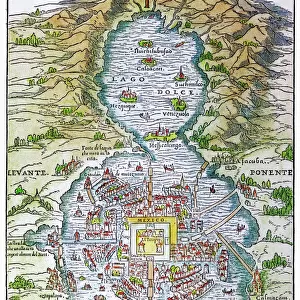
Map of South America, from a Spanish Atlas, 1582
Unleash your creativity and transform your space into a visual masterpiece!
duncan1890
Media ID 31661193
© duncan1890
Amazon Region Amazon River Brazil Circa 15th Century Colombia Equipment Latin American Culture Medieval Middle Ages Navigational Equipment Past Peru Retro Revival South America South American Culture Styles The Americas Traditional Culture Uruguay Amazonia Obsolete
Mouse Pad
Standard Size Mouse Pad 7.75" x 9..25". High density Neoprene w linen surface. Easy to clean, stain resistant finish. Rounded corners.
Archive quality photographic print in a durable wipe clean mouse mat with non slip backing. Works with all computer mice
Estimated Image Size (if not cropped) is 23.7cm x 17.6cm (9.3" x 6.9")
Estimated Product Size is 23.7cm x 20.2cm (9.3" x 8")
These are individually made so all sizes are approximate
Artwork printed orientated as per the preview above, with landscape (horizontal) orientation to match the source image.
FEATURES IN THESE COLLECTIONS
> Fine Art Storehouse
> Map
> Historical Maps
> Arts
> Art Movements
> Medieval Art
> Arts
> Landscape paintings
> Waterfall and river artworks
> River artworks
> Europe
> Spain
> Related Images
> Historic
> Historical fashion trends
> Medieval fashion trends
> Maps and Charts
> Related Images
EDITORS COMMENTS
This print takes us back in time to the 16th century, with a beautifully detailed "Map of South America" from a Spanish Atlas dating back to 1582. A true relic of cartography, this retro revival piece showcases the rich history and cultural heritage of South America during the Middle Ages. The image transports us deep into the heart of Amazonia, where ancient civilizations thrived amidst lush landscapes and winding rivers. The obsolete yet mesmerizing engraved illustration captures the essence of traditional Latin American culture, offering a glimpse into a bygone era. Vibrant colors bring life to this antique map, highlighting countries such as Uruguay, Peru, Colombia, and Brazil. It is fascinating to see how these nations have evolved over centuries while still preserving their unique identities. As we explore this medieval masterpiece, it becomes evident that navigational equipment has come a long way since then. Yet even without modern technology or GPS systems, explorers once relied on maps like these to navigate through uncharted territories along the mighty Amazon River. This image not only serves as an homage to historical styles but also reminds us of our connection with the past. It invites contemplation about how far we have come while honoring the traditions and cultures that shaped South America's vibrant tapestry. Let Duncan1890's artistry transport you on a journey through time and immerse yourself in this old-fashioned treasure trove of knowledge.
MADE IN THE USA
Safe Shipping with 30 Day Money Back Guarantee
FREE PERSONALISATION*
We are proud to offer a range of customisation features including Personalised Captions, Color Filters and Picture Zoom Tools
SECURE PAYMENTS
We happily accept a wide range of payment options so you can pay for the things you need in the way that is most convenient for you
* Options may vary by product and licensing agreement. Zoomed Pictures can be adjusted in the Cart.