Mouse Mat > Europe > Italy > Lazio > Rome
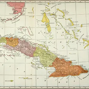
Mouse Mat : Geography map: double page of an Atlas showing maps and descriptive texts of the islands of Jamaica and Cuba in the Caribbean. Engraving of the 17th century. Biblioteca Angelica, Rome


![]()
Home Decor From Fine Art Finder
Geography map: double page of an Atlas showing maps and descriptive texts of the islands of Jamaica and Cuba in the Caribbean. Engraving of the 17th century. Biblioteca Angelica, Rome
VEN5030435 Geography map: double page of an Atlas showing maps and descriptive texts of the islands of Jamaica and Cuba in the Caribbean. Engraving of the 17th century. Biblioteca Angelica, Rome; (add.info.: Geography map: double page of an Atlas showing maps and descriptive texts of the islands of Jamaica and Cuba in the Caribbean. Engraving of the 17th century. Biblioteca Angelica, Rome); © Marage Photos
Media ID 38426178
© © Marage Photos / Bridgeman Images
17eme Siecle Amerique Centrale Amerique Du Nord Caribbean Carte Geographique Central America Cuba Cuba Cubain Cubaine Cubains Cubaines Cuban Etats Unis Geographie Jamaica Jamaican Livre Livre Ouvert Open Book Stockravenna 17th Centuries Etats Unis Etats Unis Usa United States Geographical Map
Mouse Pad
Standard Size Mouse Pad 7.75" x 9..25". High density Neoprene w linen surface. Easy to clean, stain resistant finish. Rounded corners.
Archive quality photographic print in a durable wipe clean mouse mat with non slip backing. Works with all computer mice
Estimated Image Size (if not cropped) is 23.7cm x 16.5cm (9.3" x 6.5")
Estimated Product Size is 23.7cm x 20.2cm (9.3" x 8")
These are individually made so all sizes are approximate
Artwork printed orientated as per the preview above, with landscape (horizontal) orientation to match the source image.
FEATURES IN THESE COLLECTIONS
> Europe
> Italy
> Lazio
> Rome
> Maps and Charts
> Early Maps
> Maps and Charts
> Related Images
> North America
> Cuba
> Maps
> North America
> Cuba
> Related Images
> North America
> Jamaica
> Maps
> North America
> Jamaica
> Related Images
> North America
> United States of America
> Maps
> Popular Themes
> North Island
EDITORS COMMENTS
This stunning 17th-century engraving from the Biblioteca Angelica in Rome showcases a double page of an Atlas featuring detailed maps and descriptive texts of the islands of Jamaica and Cuba in the Caribbean. The intricate details and historical significance of this geography map provide a fascinating glimpse into the past.
The carefully crafted illustrations offer a glimpse into the early exploration and mapping of these tropical islands, capturing their unique geography and topography with precision. From the lush landscapes of Jamaica to the vibrant culture of Cuba, each island is depicted with artistic flair and attention to detail.
As you study this print, you can almost imagine yourself sailing through the crystal-clear waters surrounding these exotic destinations. The rich history and cultural heritage of Jamaica and Cuba come alive on these pages, inviting you to delve deeper into their stories.
Whether you're a history buff, geography enthusiast, or simply appreciate fine art, this vintage map is sure to captivate your imagination. It serves as a reminder of the enduring allure of these Caribbean islands and their importance in shaping our understanding of the world around us.
MADE IN THE USA
Safe Shipping with 30 Day Money Back Guarantee
FREE PERSONALISATION*
We are proud to offer a range of customisation features including Personalised Captions, Color Filters and Picture Zoom Tools
SECURE PAYMENTS
We happily accept a wide range of payment options so you can pay for the things you need in the way that is most convenient for you
* Options may vary by product and licensing agreement. Zoomed Pictures can be adjusted in the Basket.