Metal Print > Arts > Artists > O > Abraham Ortelius
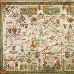
Metal Print : Map of the Nile Delta and of ancient city of Carthage, from Theatrum Orbis Terrarum by Abraham Ortelius, 1528-1598, Antwerp, 1570


![]()
Metal Prints from Universal Images Group (UIG)
Map of the Nile Delta and of ancient city of Carthage, from Theatrum Orbis Terrarum by Abraham Ortelius, 1528-1598, Antwerp, 1570
Cartography, 16th century. Map of the Nile Delta and of ancient city of Carthage, from Theatrum Orbis Terrarum by Abraham Ortelius (1528-1598), Antwerp, 1570
Universal Images Group (UIG) manages distribution for many leading specialist agencies worldwide
Media ID 9570615
© DEA / A. DAGLI ORTI
16th Century Carthage Latin Script Manuscript Nile River
16"x20" (51x41cm) Metal Print
Discover the rich history of ancient civilizations with our Media Storehouse Metal Prints featuring a captivating map of the Nile Delta and the ancient city of Carthage. Hailing from Abraham Ortelius's seminal work, "Theatrum Orbis Terrarum" (1570), this exquisite map showcases intricate detail and precision, transporting you back to the 16th century. The vintage cartography, brought to life through our premium metal print process, adds an elegant and timeless touch to any space. Embrace history and add a touch of sophistication to your home or office decor with this stunning piece.
Made with durable metal and luxurious printing techniques, our metal photo prints go beyond traditional canvases, adding a cool, modern touch to your space. Wall mount on back. Eco-friendly 100% post-consumer recycled ChromaLuxe aluminum surface. The thickness of the print is 0.045". Featuring a Scratch-resistant surface and Rounded corners. Backing hangers are attached to the back of the print and float the print 1/2-inch off the wall when hung, the choice of hanger may vary depending on size and International orders will come with Float Mount hangers only. Finished with a brilliant white high gloss surface for unsurpassed detail and vibrance. Printed using Dye-Sublimation and for best care we recommend a non-ammonia glass cleaner, water, or isopropyl (rubbing) alcohol to prevent harming the print surface. We recommend using a clean, lint-free cloth to wipe off the print. The ultra-hard surface is scratch-resistant, waterproof and weatherproof. Avoid direct sunlight exposure.
Made with durable metal and luxurious printing techniques, metal prints bring images to life and add a modern touch to any space
Estimated Image Size (if not cropped) is 40.6cm x 50.8cm (16" x 20")
Estimated Product Size is 41.2cm x 51.4cm (16.2" x 20.2")
These are individually made so all sizes are approximate
Artwork printed orientated as per the preview above, with portrait (vertical) orientation to match the source image.
FEATURES IN THESE COLLECTIONS
> Arts
> Artists
> O
> Abraham Ortelius
> Maps and Charts
> Abraham Ortelius
> Maps and Charts
> Early Maps
> Maps and Charts
> Related Images
> Universal Images Group (UIG)
> Art
> Painting, Sculpture & Prints
> Cartography
EDITORS COMMENTS
This print showcases a remarkable piece of cartographic history - the Map of the Nile Delta and ancient city of Carthage. Created by Abraham Ortelius, a renowned Flemish cartographer from Antwerp in the late 16th century, this map is an exquisite example of his influential work. Ortelius's masterpiece, featured in Theatrum Orbis Terrarum, takes us on a journey through time and space. With intricate detail and precision, he beautifully captures the physical geography of the Nile Delta region as well as the ancient city of Carthage. This map serves as both an invaluable historical document and a stunning piece of art. The composition is horizontal, allowing viewers to immerse themselves in every minute detail presented before them. Through careful brushstrokes and delicate use of color, Ortelius breathes life into this illustration. The Latin script adds an air of authenticity to this manuscript-like creation. As we gaze upon this image, we are transported back to a time when exploration was at its peak. It reminds us that maps were not just tools for navigation but also works of art that celebrated human curiosity about our world. In this particular rendition from Universal Images Group (UIG), no people are present; instead, it focuses solely on showcasing the magnificence and significance behind Ortelius's creation. Let this photograph print serve as a reminder that even centuries later, these historical artifacts continue to captivate our imagination with their timeless beauty.
MADE IN THE USA
Safe Shipping with 30 Day Money Back Guarantee
FREE PERSONALISATION*
We are proud to offer a range of customisation features including Personalised Captions, Color Filters and Picture Zoom Tools
SECURE PAYMENTS
We happily accept a wide range of payment options so you can pay for the things you need in the way that is most convenient for you
* Options may vary by product and licensing agreement. Zoomed Pictures can be adjusted in the Cart.