Metal Print > Arts > Artists > L > George Landseer
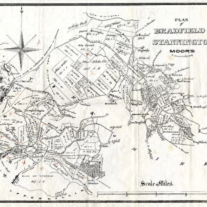
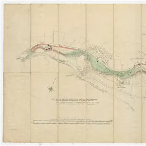
Metal Print : Plan of land along the River Rivelin, Sheffield, 1784


![]()
Metal Prints From Sheffield City Archives
Plan of land along the River Rivelin, Sheffield, 1784
Full title: A plan of the Holme Wheels, and of the lands of the Earl of Surrey held with them by George Spooner and William Hellifield.
Scale 2 chains : 1 inch [40 inches : 1 mile]
Surveyor: William Fairbank II.
Spooner Wheel and dam clearly shown as well as land along the banks of the River Rivelin.
Numerical list with descriptions and acreages.
From an original at Sheffield Libraries: arc03007
Sheffield City Archives and Local Studies Library has an unrivalled collection of images of Sheffield, England
Media ID 19225931
© Sheffield City Council - All Rights Reserved
Bradfield Sheffield Waterwheels Yorkshire
16"x20" (51x41cm) Metal Print
Bring history to life with our stunning Metal Prints from Media Storehouse. This particular piece features an intriguing Plan of Land along the River Rivelin in Sheffield, dating back to 1784. Originally titled "A plan of the Holme Wheels, and of the lands of the Earl of Surrey held with them by George Spooner and William Hellifield," this rare map from Sheffield City Archives is now available in a modern, sleek metal print. The vibrant colors and high-quality finish of our Metal Prints make for a beautiful addition to any home or office, while the historical significance of this particular piece adds a unique touch. Order yours today and bring a piece of Sheffield's rich history into your space.
Made with durable metal and luxurious printing techniques, our metal photo prints go beyond traditional canvases, adding a cool, modern touch to your space. Wall mount on back. Eco-friendly 100% post-consumer recycled ChromaLuxe aluminum surface. The thickness of the print is 0.045". Featuring a Scratch-resistant surface and Rounded corners. Backing hangers are attached to the back of the print and float the print 1/2-inch off the wall when hung, the choice of hanger may vary depending on size and International orders will come with Float Mount hangers only. Finished with a brilliant white high gloss surface for unsurpassed detail and vibrance. Printed using Dye-Sublimation and for best care we recommend a non-ammonia glass cleaner, water, or isopropyl (rubbing) alcohol to prevent harming the print surface. We recommend using a clean, lint-free cloth to wipe off the print. The ultra-hard surface is scratch-resistant, waterproof and weatherproof. Avoid direct sunlight exposure.
Made with durable metal and luxurious printing techniques, metal prints bring images to life and add a modern touch to any space
Estimated Image Size (if not cropped) is 40.6cm x 50.8cm (16" x 20")
Estimated Product Size is 41.2cm x 51.4cm (16.2" x 20.2")
These are individually made so all sizes are approximate
Artwork printed orientated as per the preview above, with portrait (vertical) orientation to match the source image.
FEATURES IN THESE COLLECTIONS
> Arts
> Artists
> L
> George Landseer
> Europe
> France
> Canton
> Landes
> Europe
> United Kingdom
> England
> Surrey
> Related Images
> Europe
> United Kingdom
> England
> Yorkshire
> Holme
> Europe
> United Kingdom
> England
> Yorkshire
> Related Images
> Europe
> United Kingdom
> England
> Yorkshire
> Sheffield
> Europe
> United Kingdom
> England
> Yorkshire
> Well
EDITORS COMMENTS
This print from Sheffield City Archives takes us back to the year 1784, offering a glimpse into the rich history of land along the River Rivelin in Sheffield. The full title of this remarkable piece is "A plan of the Holme Wheels, and of the lands of the Earl of Surrey held with them by George Spooner and William Hellifield". Surveyed by William Fairbank II, it showcases intricate details such as Spooner Wheel and dam, while also highlighting the beautiful expanse of land that stretches along the riverbanks. The scale used for this plan is truly impressive - 2 chains to 1 inch or 40 inches to 1 mile. This meticulous attention to detail allows viewers to immerse themselves in every aspect captured within this image. Additionally, a numerical list accompanies this print, providing descriptions and acreages for each specific area depicted. Preserved at Sheffield Libraries under reference arc03007, this original piece holds immense historical significance for Yorkshire's Bradfield region. It offers an invaluable window into how these lands were utilized during that era. As we admire this photograph print today, let us appreciate its beauty and acknowledge its importance in documenting our past. It serves as a reminder not only of our connection to nature but also how human ingenuity has shaped landscapes throughout time.
MADE IN THE USA
Safe Shipping with 30 Day Money Back Guarantee
FREE PERSONALISATION*
We are proud to offer a range of customisation features including Personalised Captions, Color Filters and Picture Zoom Tools
SECURE PAYMENTS
We happily accept a wide range of payment options so you can pay for the things you need in the way that is most convenient for you
* Options may vary by product and licensing agreement. Zoomed Pictures can be adjusted in the Basket.

![Maps of Several Parcels of Land proposed to be exchanged, Bradfield, [c. 1750 - 1760]](/sq/716/maps-parcels-land-proposed-exchanged-bradfield-19192402.jpg.webp)
![A map of Wm. Carrs Farm at Stanington [Stannington], 1747](/sq/716/map-wm-carrs-farm-stanington-stannington-1747-19192400.jpg.webp)


![A survey of a parcel of Land called Platts... [Platts Farm, Ughill], 1728](/sq/716/survey-parcel-land-called-platts-19225923.jpg.webp)