Metal Print > Europe > Italy > Lazio > Civitavecchia
Metal Print : Transporting the Montecitorio Obelisk


![]()
Metal Prints From Science Photo Library
Transporting the Montecitorio Obelisk
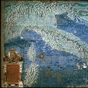
Roman Cargo Ship, reconstructed in the form of a raft, being used to transport the Montecitorio obelisk from Egypt to Rome in 10 BC. This obelisk is an ancient Egyptian, red granite obelisk of Psammetichus II (595-589 BC) from Heliopolis. Augustus erected it as the gnomon of the Solarium Augusti, his giant sundial, in the Campus Martius, Rome. It is now in the Piazza Montecitorio. Detail from a map of Civitavecchia in the Gallery of Maps in the Vatican Museum. These maps were commissioned between 1578 and 1580 to show the regions of Italy and territories of the church. They are based on the work of Ignazio Danti, a 16th century Italian priest, mathematician, astronomer and cosmographer, and are an important record of 16th century geography
Science Photo Library features Science and Medical images including photos and illustrations
Media ID 6320783
© Sheila Terry
1500s 16th Century Ancient Egypt Augustus Earth Science Gallery Of Maps Gnomon Ignazio Danti Italian Italy Rome Sciences Civitavecchia
16"x24" (61x41cm) Metal Print
Step back in time with our stunning Media Storehouse Metal Prints, featuring the captivating image of a Roman cargo ship transporting the Montecitorio Obelisk from Egypt to Rome in 10 BC. This intricately reconstructed raft, carrying the iconic ancient monument, is brought to life in brilliant detail on our high-quality metal prints. Each print is meticulously crafted to showcase the rich textures and vibrant colors of the original Science Photo Library image. Add a touch of history and elegance to your home or office with this impressive and conversation-starting piece of art.
Made with durable metal and luxurious printing techniques, our metal photo prints go beyond traditional canvases, adding a cool, modern touch to your space. Wall mount on back. Eco-friendly 100% post-consumer recycled ChromaLuxe aluminum surface. The thickness of the print is 0.045". Featuring a Scratch-resistant surface and Rounded corners. Backing hangers are attached to the back of the print and float the print 1/2-inch off the wall when hung, the choice of hanger may vary depending on size and International orders will come with Float Mount hangers only. Finished with a brilliant white high gloss surface for unsurpassed detail and vibrance. Printed using Dye-Sublimation and for best care we recommend a non-ammonia glass cleaner, water, or isopropyl (rubbing) alcohol to prevent harming the print surface. We recommend using a clean, lint-free cloth to wipe off the print. The ultra-hard surface is scratch-resistant, waterproof and weatherproof. Avoid direct sunlight exposure.
Made with durable metal and luxurious printing techniques, metal prints bring images to life and add a modern touch to any space
Estimated Product Size is 61.5cm x 41.2cm (24.2" x 16.2")
These are individually made so all sizes are approximate
Artwork printed orientated as per the preview above, with landscape (horizontal) orientation to match the source image.
FEATURES IN THESE COLLECTIONS
> Africa
> Egypt
> Related Images
> Arts
> Artists
> R
> Roman Roman
> Europe
> Italy
> Lazio
> Civitavecchia
> Europe
> Italy
> Lazio
> Rome
> Maps and Charts
> Early Maps
> Maps and Charts
> Italy
> Maps and Charts
> Related Images
EDITORS COMMENTS
This print showcases the remarkable feat of transporting the Montecitorio Obelisk, an ancient Egyptian artifact, from Egypt to Rome in 10 BC. The image depicts a reconstructed Roman cargo ship fashioned into a raft, specifically designed for this monumental task. The obelisk itself is a magnificent red granite structure dating back to the reign of Psammetichus II in Heliopolis. Commissioned by Augustus, the obelisk was erected as the gnomon of the Solarium Augusti, serving as a colossal sundial in Rome's Campus Martius. Today, it proudly stands in Piazza Montecitorio. This detailed snapshot is taken from one of Ignazio Danti's maps displayed at the Vatican Museum's Gallery of Maps. Created between 1578 and 1580 under papal patronage, these maps were intended to showcase Italy's regions and territories belonging to the Church. Ignazio Danti himself was not only an esteemed Italian priest but also excelled as a mathematician, astronomer, and cosmographer during the 16th century. Consequently, his cartographic works serve as invaluable records documenting geography during that era. Transporting such an immense historical treasure across vast distances reflects both Italy's rich heritage and its dedication to preserving ancient wonders. This photograph encapsulates centuries-old connections between civilizations while celebrating scientific advancements made possible through disciplines like astronomy and earth science.
MADE IN THE USA
Safe Shipping with 30 Day Money Back Guarantee
FREE PERSONALISATION*
We are proud to offer a range of customisation features including Personalised Captions, Color Filters and Picture Zoom Tools
SECURE PAYMENTS
We happily accept a wide range of payment options so you can pay for the things you need in the way that is most convenient for you
* Options may vary by product and licensing agreement. Zoomed Pictures can be adjusted in the Basket.