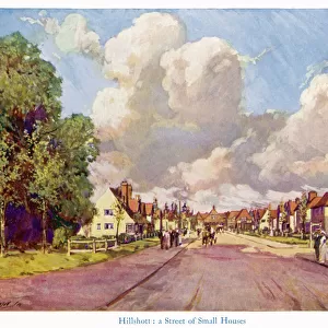
Metal Print > Arts > Artists > O > Oceanic Oceanic
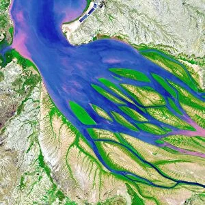
Metal Print : Bombetoka Bay, Madagascar


![]()
Metal Prints from Science Photo Library
Bombetoka Bay, Madagascar
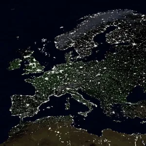
Bombetoka Bay, Madagascar, satellite image. This bay links the Betsiboka River (at right) with the Mozambique Channel (top left), part of the Indian Ocean. The river carries a large amount of sediment, which has led to the development of several silt islands. The edges of these are green as they have been colonised by mangroves. The heavy sediment load is largely due to deforestation along the rivers banks to make way for agriculture. Crops including rice and coffee are extensively grown in the area. This image, which is around 30 kilometres square, was taken by the ASTER instrument on the Terra satellite
Science Photo Library features Science and Medical images including photos and illustrations
Media ID 1705681
© NASA/SCIENCE PHOTO LIBRARY
Agricultural Agriculture Aster Deforestation Earth Observation Estuarine Estuary Farming From Space Inlet Island Madagascar Mangroves Satellite Image Sediment Silt Terra Vegetation Mozambique Channel
20"x24" (61x51cm) Metal Print
Breathtakingly beautiful, our Metal Prints feature this stunning satellite image of Bombetoka Bay in Madagascar, captured by Science Photo Library. Witness the mesmerizing connection between the Betsiboka River and the Mozambique Channel of the Indian Ocean. Our high-quality metal prints are not just decorative pieces, they're a conversation starter and a reminder of the wonders our world holds. Order yours today and bring a piece of the natural world into your home or office.
Made with durable metal and luxurious printing techniques, our metal photo prints go beyond traditional canvases, adding a cool, modern touch to your space. Wall mount on back. Eco-friendly 100% post-consumer recycled ChromaLuxe aluminum surface. The thickness of the print is 0.045". Featuring a Scratch-resistant surface and Rounded corners. Backing hangers are attached to the back of the print and float the print 1/2-inch off the wall when hung, the choice of hanger may vary depending on size and International orders will come with Float Mount hangers only. Finished with a brilliant white high gloss surface for unsurpassed detail and vibrance. Printed using Dye-Sublimation and for best care we recommend a non-ammonia glass cleaner, water, or isopropyl (rubbing) alcohol to prevent harming the print surface. We recommend using a clean, lint-free cloth to wipe off the print. The ultra-hard surface is scratch-resistant, waterproof and weatherproof. Avoid direct sunlight exposure.
Made with durable metal and luxurious printing techniques, metal prints bring images to life and add a modern touch to any space
Estimated Image Size (if not cropped) is 50.8cm x 60.9cm (20" x 24")
Estimated Product Size is 51.4cm x 61.5cm (20.2" x 24.2")
These are individually made so all sizes are approximate
Artwork printed orientated as per the preview above, with portrait (vertical) orientation to match the source image.
FEATURES IN THESE COLLECTIONS
> Africa
> Madagascar
> Related Images
> Africa
> Mozambique
> Related Images
> Arts
> Artists
> O
> Oceanic Oceanic
> Arts
> Landscape paintings
> Waterfall and river artworks
> River artworks
> Science
> Space Exploration
> Related Images
> Science
> Space Exploration
> Satellite Imagery
> Science Photo Library
> Aerial and Satellite
EDITORS COMMENTS
This print showcases Bombetoka Bay in Madagascar, a stunning satellite image that reveals the intricate connection between nature and human activity. The bay serves as a vital link between the Betsiboka River and the Mozambique Channel, forming a gateway from the river to the vast Indian Ocean. However, what makes this image truly fascinating is the visible impact of deforestation along the riverbanks. The large amount of sediment carried by the Betsiboka River has given rise to several silt islands within Bombetoka Bay. These islands are adorned with vibrant green edges, thanks to their colonization by mangroves. Unfortunately, this heavy sediment load is primarily caused by deforestation driven by agricultural practices in order to make way for crops like rice and coffee. As we gaze upon this 30-kilometer square image captured by ASTER instrument on Terra satellite, it becomes evident how our actions can shape landscapes on such a grand scale. This photograph not only highlights the beauty of Madagascar's geography but also serves as a reminder of our responsibility towards preserving its delicate ecosystem. Taken on August 23rd, 2000, this remarkable Earth observation from space provides us with valuable insights into environmental changes occurring over time. Science Photo Library presents us with an opportunity to appreciate both natural wonders and human influence through their thought-provoking imagery.
MADE IN THE USA
Safe Shipping with 30 Day Money Back Guarantee
FREE PERSONALISATION*
We are proud to offer a range of customisation features including Personalised Captions, Color Filters and Picture Zoom Tools
SECURE PAYMENTS
We happily accept a wide range of payment options so you can pay for the things you need in the way that is most convenient for you
* Options may vary by product and licensing agreement. Zoomed Pictures can be adjusted in the Cart.