Metal Print > Animals > Mammals > Macropodidae > Parma
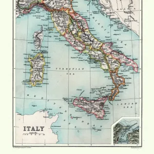
Metal Print : Map of Italy in 1836 by Ab. Bartolomeo Borghi


![]()
Metal Prints From Mary Evans Picture Library
Map of Italy in 1836 by Ab. Bartolomeo Borghi
Map of Italy in 1836. Showing the kingdoms of Sardinia, Lombardy, Venice, Rome, Tuscany, Parma, Naples and Corsica. Map by Ab. Bartolomeo Borghi, Florence. l Italia dell Ab. B. Borghi, Firenze 1836. Handcoloured copperplate engraving by Giarre from Giulio Ferrarios Costumes Ancient and Modern of the Peoples of the World, Il Costume Antico e Moderno, Florence, 1842
Mary Evans Picture Library makes available wonderful images created for people to enjoy over the centuries
Media ID 23383254
© Florilegius
1836 Alabaster Antico Arrows Bartolomeo Corsi Etruscan Ferrario Giulio Ladders Moderno Peoples Scale Shields Siege Thebes Volterra Walls Warriors
16"x20" (51x41cm) Metal Print
Step back in time with our exquisite Metal Print of the Map of Italy in 1836 by Ab. Bartolomeo Borghi from Mary Evans Picture Library. This intricately detailed map, originally published in Florence, showcases the political landscape of Italy during that era. With a focus on the kingdoms of Sardinia, Lombardy, Venice, Rome, Tuscany, Parma, Naples, and Corsica, this vintage map is a must-have for history enthusiasts, travelers, and anyone with an appreciation for the beauty of historical cartography. Our high-quality Metal Print preserves the rich, antique look of the original map, making it a stunning addition to any wall in your home or office.
Made with durable metal and luxurious printing techniques, our metal photo prints go beyond traditional canvases, adding a cool, modern touch to your space. Wall mount on back. Eco-friendly 100% post-consumer recycled ChromaLuxe aluminum surface. The thickness of the print is 0.045". Featuring a Scratch-resistant surface and Rounded corners. Backing hangers are attached to the back of the print and float the print 1/2-inch off the wall when hung, the choice of hanger may vary depending on size and International orders will come with Float Mount hangers only. Finished with a brilliant white high gloss surface for unsurpassed detail and vibrance. Printed using Dye-Sublimation and for best care we recommend a non-ammonia glass cleaner, water, or isopropyl (rubbing) alcohol to prevent harming the print surface. We recommend using a clean, lint-free cloth to wipe off the print. The ultra-hard surface is scratch-resistant, waterproof and weatherproof. Avoid direct sunlight exposure.
Made with durable metal and luxurious printing techniques, metal prints bring images to life and add a modern touch to any space
Estimated Image Size (if not cropped) is 40.6cm x 50.8cm (16" x 20")
Estimated Product Size is 41.2cm x 51.4cm (16.2" x 20.2")
These are individually made so all sizes are approximate
Artwork printed orientated as per the preview above, with portrait (vertical) orientation to match the source image.
FEATURES IN THESE COLLECTIONS
> Mary Evans Prints Online
> New Images August 2021
> Animals
> Mammals
> Macropodidae
> Parma
> Arts
> Artists
> E
> Etruscan Etruscan
> Arts
> Artists
> F
> Giulio Ferrario
> Europe
> Greece
> Related Images
> Europe
> Italy
> Campania
> Naples
> Europe
> Italy
> Lazio
> Rome
EDITORS COMMENTS
This stunning handcoloured copperplate engraving, created by Ab. Bartolomeo Borghi in Florence in 1836, offers a captivating glimpse into the political landscape of Italy during that era. The map meticulously depicts the various kingdoms and regions of Italy, including Sardinia, Lombardy, Venice, Rome, Tuscany, Parma, Naples, and Corsica. The intricate details of the map extend beyond political boundaries, showcasing the rich history and culture of each region. Etruscan warriors, clad in armor and armed with arrows, are depicted defending their city, Thebes, atop the fortified walls. Greek influences are evident in the illustration, with warriors wearing shields adorned with intricate designs and carrying alabaster urns. The map also highlights notable cities and landmarks, such as Volterra, known for its Etruscan ruins and production of alabaster. This map was originally published as part of Giulio Ferrario's "Costumes Ancient and Modern of the Peoples of the World," which was published in Florence in 1842. The map and accompanying illustrations offer a unique perspective on historical fashion and the cultural influences that shaped Italy during the 19th century. The meticulous handcolouring adds an additional layer of detail and beauty to the already intriguing map, making it a valuable historical artifact and an essential addition to any collection focused on Italian history or cartography.
MADE IN THE USA
Safe Shipping with 30 Day Money Back Guarantee
FREE PERSONALISATION*
We are proud to offer a range of customisation features including Personalised Captions, Color Filters and Picture Zoom Tools
SECURE PAYMENTS
We happily accept a wide range of payment options so you can pay for the things you need in the way that is most convenient for you
* Options may vary by product and licensing agreement. Zoomed Pictures can be adjusted in the Basket.