Metal Print > Europe > Italy > Tuscany > Florence
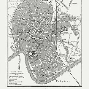
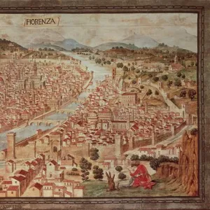
Metal Print : Map of Florence


![]()
Metal Prints from Mary Evans Picture Library
Map of Florence
Map of the city of Florence, Italy and the River Arno Date: 19th century
Mary Evans Picture Library makes available wonderful images created for people to enjoy over the centuries
Media ID 7403415
© Mary Evans Picture Library 2015 - https://copyrighthub.org/s0/hub1/creation/maryevans/MaryEvansPictureID/10474584
16"x20" (51x41cm) Metal Print
Discover the timeless beauty of Florence with our exquisite Metal Prints from Media Storehouse. This stunning representation of a 19th century map of the historic city and the River Arno, sourced from the extensive collection at Mary Evans Prints Online, is brought to life in vivid detail on a sleek, durable metal surface. Each print is individually crafted using high-definition printing technology and a protective coating to ensure long-lasting brilliance. Transform any space into an art gallery with this captivating piece, perfect for adding a touch of history and sophistication to your home or office decor.
Made with durable metal and luxurious printing techniques, our metal photo prints go beyond traditional canvases, adding a cool, modern touch to your space. Wall mount on back. Eco-friendly 100% post-consumer recycled ChromaLuxe aluminum surface. The thickness of the print is 0.045". Featuring a Scratch-resistant surface and Rounded corners. Backing hangers are attached to the back of the print and float the print 1/2-inch off the wall when hung, the choice of hanger may vary depending on size and International orders will come with Float Mount hangers only. Finished with a brilliant white high gloss surface for unsurpassed detail and vibrance. Printed using Dye-Sublimation and for best care we recommend a non-ammonia glass cleaner, water, or isopropyl (rubbing) alcohol to prevent harming the print surface. We recommend using a clean, lint-free cloth to wipe off the print. The ultra-hard surface is scratch-resistant, waterproof and weatherproof. Avoid direct sunlight exposure.
Made with durable metal and luxurious printing techniques, metal prints bring images to life and add a modern touch to any space
Estimated Image Size (if not cropped) is 50.8cm x 40.6cm (20" x 16")
Estimated Product Size is 51.4cm x 41.2cm (20.2" x 16.2")
These are individually made so all sizes are approximate
Artwork printed orientated as per the preview above, with landscape (horizontal) orientation to match the source image.
FEATURES IN THESE COLLECTIONS
> Mary Evans Prints Online
> National Archives
> Arts
> Landscape paintings
> Waterfall and river artworks
> River artworks
> Europe
> Italy
> Related Images
> Europe
> Italy
> Tuscany
> Florence
> Maps and Charts
> Italy
> Maps and Charts
> Related Images
EDITORS COMMENTS
1. Title: A Glance into the Past: A 19th Century Map of Florence and the River Arno This antique map print, hailing from the 19th century, offers a fascinating glimpse into the history and layout of Florence, the birthplace of the Renaissance in Italy. The map, which dates back to an era of artistic and intellectual flourishing, beautifully illustrates the city's urban fabric and the meandering River Arno that has shaped its development. The map, meticulously crafted, reveals the historical center of Florence, with its iconic landmarks such as the Duomo, Ponte Vecchio, and the Uffizi Gallery, all prominently displayed. The intricate details of the map extend beyond the city limits, providing an insight into the surrounding countryside and the picturesque villages nestled along the banks of the River Arno. The map's antique charm is further accentuated by the use of an intricate yet elegant cartographic style, which was common during the 19th century. The map's borders are adorned with decorative elements, and the river is depicted with a winding, sinuous path, reflecting the natural beauty and the fluidity of the waterway. A closer look at the map reveals the presence of various points of interest, such as churches, palaces, and fortifications, which add to the historical significance of the print. The map also features an inset in the bottom right corner, which provides a more detailed view of the city's layout, complete with street names and the location of key landmarks. This 19th century map of Florence and the River Arno is a testament to the rich history and cultural heritage of one of Europe's most iconic cities. It serves as a reminder of the past, inviting us to explore the stories and secrets that lie within its intricately drawn lines and vibrant, historical landscape.
MADE IN THE USA
Safe Shipping with 30 Day Money Back Guarantee
FREE PERSONALISATION*
We are proud to offer a range of customisation features including Personalised Captions, Color Filters and Picture Zoom Tools
SECURE PAYMENTS
We happily accept a wide range of payment options so you can pay for the things you need in the way that is most convenient for you
* Options may vary by product and licensing agreement. Zoomed Pictures can be adjusted in the Cart.