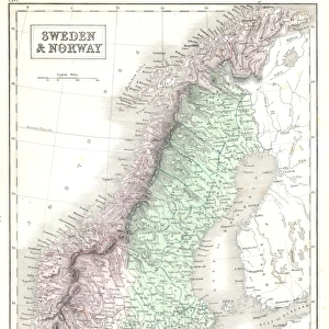
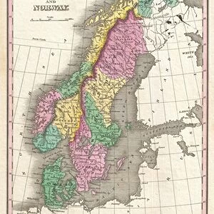
Metal Print : 1850, Mitchell Map of Sweden and Norway, topography, cartography, geography, land


![]()
Metal Prints From Liszt Collection
1850, Mitchell Map of Sweden and Norway, topography, cartography, geography, land
1850, Mitchell Map of Sweden and Norway
Liszt Collection of nineteenth-century engravings and images to browse and enjoy
Media ID 14007326
© Artokoloro Quint Lox Limited
1850 Antique Map Latitude Longitude Mappa Mundi Old Antique Plan Old Antique View Ols Antique Map Rare Old Maps Topo
16"x20" (51x41cm) Metal Print
Discover the rich history and intricate details of 1850's cartography with our Media Storehouse Metal Prints featuring the Mitchell Map of Sweden and Norway. This exquisite piece showcases the topography and geography of the region during a pivotal time in history. Each print is meticulously crafted on high-quality metal, bringing the intricate lines and vibrant colors of the Mitchell Map to life. The land from the Liszt Collection is beautifully preserved, allowing you to explore the topography and cartography of Sweden and Norway as if you were there in 1850. Add this stunning piece to your home or office for a unique and educational display.
Made with durable metal and luxurious printing techniques, our metal photo prints go beyond traditional canvases, adding a cool, modern touch to your space. Wall mount on back. Eco-friendly 100% post-consumer recycled ChromaLuxe aluminum surface. The thickness of the print is 0.045". Featuring a Scratch-resistant surface and Rounded corners. Backing hangers are attached to the back of the print and float the print 1/2-inch off the wall when hung, the choice of hanger may vary depending on size and International orders will come with Float Mount hangers only. Finished with a brilliant white high gloss surface for unsurpassed detail and vibrance. Printed using Dye-Sublimation and for best care we recommend a non-ammonia glass cleaner, water, or isopropyl (rubbing) alcohol to prevent harming the print surface. We recommend using a clean, lint-free cloth to wipe off the print. The ultra-hard surface is scratch-resistant, waterproof and weatherproof. Avoid direct sunlight exposure.
Made with durable metal and luxurious printing techniques, metal prints bring images to life and add a modern touch to any space
Estimated Image Size (if not cropped) is 40.6cm x 50.8cm (16" x 20")
Estimated Product Size is 41.2cm x 51.4cm (16.2" x 20.2")
These are individually made so all sizes are approximate
Artwork printed orientated as per the preview above, with portrait (vertical) orientation to match the source image.
EDITORS COMMENTS
This print showcases the remarkable 1850 Mitchell Map of Sweden and Norway, a true masterpiece in the realms of topography, cartography, and geography. With its intricate details and precise land representations, this vintage map takes us on a journey through time to explore the ancient history of these Scandinavian lands. The illustration is a testament to the artistry involved in creating such historical maps. Its decorative elements add an aesthetic charm that transports us back to an era when navigation relied heavily on paper maps like this one. The aged appearance further enhances its allure, evoking a sense of nostalgia for bygone eras. As we gaze upon this rare old map, we are reminded of the importance placed on geographical knowledge during times when exploration was at its peak. This particular piece offers invaluable insights into the region's past and serves as a valuable resource for researchers and enthusiasts alike. With its grid lines denoting latitude and longitude, this Mitchell Map provides not only geographic accuracy but also serves as an educational tool for understanding Earth's diverse landscapes. It stands as a mappa mundi—a representation of our world—capturing both space and region within its meticulously crafted borders. This print from Liszt Collection invites us to appreciate the beauty found in historical cartography while igniting our curiosity about distant lands explored centuries ago.
MADE IN THE USA
Safe Shipping with 30 Day Money Back Guarantee
FREE PERSONALISATION*
We are proud to offer a range of customisation features including Personalised Captions, Color Filters and Picture Zoom Tools
SECURE PAYMENTS
We happily accept a wide range of payment options so you can pay for the things you need in the way that is most convenient for you
* Options may vary by product and licensing agreement. Zoomed Pictures can be adjusted in the Basket.