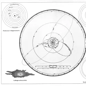
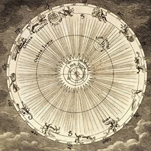
Metal Print : 1753, Homann Heirs Solar System Astronomical Chart, topography, cartography, geography


![]()
Metal Prints From Liszt Collection
1753, Homann Heirs Solar System Astronomical Chart, topography, cartography, geography
1753, Homann Heirs Solar System Astronomical Chart
Liszt Collection of nineteenth-century engravings and images to browse and enjoy
Media ID 14006666
© Artokoloro Quint Lox Limited
1753 Antique Map Latitude Longitude Mappa Mundi Old Antique Plan Old Antique View Ols Antique Map Rare Old Maps Topo
16"x20" (51x41cm) Metal Print
Discover the wonders of the cosmos with our Media Storehouse Metal Prints featuring the 1753 Homann Heirs Solar System Astronomical Chart. This intricately detailed topographical map, sourced from the esteemed Liszt Collection, showcases the solar system as it was understood during the Enlightenment era. Each print is meticulously crafted on high-quality metal, resulting in a stunning, vibrant display that brings history to life. Perfect for astronomy enthusiasts, history buffs, or anyone seeking to add a touch of intellectual sophistication to their decor. Experience the allure of the stars and the beauty of historical cartography with our Metal Prints.
Made with durable metal and luxurious printing techniques, our metal photo prints go beyond traditional canvases, adding a cool, modern touch to your space. Wall mount on back. Eco-friendly 100% post-consumer recycled ChromaLuxe aluminum surface. The thickness of the print is 0.045". Featuring a Scratch-resistant surface and Rounded corners. Backing hangers are attached to the back of the print and float the print 1/2-inch off the wall when hung, the choice of hanger may vary depending on size and International orders will come with Float Mount hangers only. Finished with a brilliant white high gloss surface for unsurpassed detail and vibrance. Printed using Dye-Sublimation and for best care we recommend a non-ammonia glass cleaner, water, or isopropyl (rubbing) alcohol to prevent harming the print surface. We recommend using a clean, lint-free cloth to wipe off the print. The ultra-hard surface is scratch-resistant, waterproof and weatherproof. Avoid direct sunlight exposure.
Made with durable metal and luxurious printing techniques, metal prints bring images to life and add a modern touch to any space
Estimated Image Size (if not cropped) is 50.8cm x 40.6cm (20" x 16")
Estimated Product Size is 51.4cm x 41.2cm (20.2" x 16.2")
These are individually made so all sizes are approximate
Artwork printed orientated as per the preview above, with landscape (horizontal) orientation to match the source image.
EDITORS COMMENTS
This print showcases the Homann Heirs Solar System Astronomical Chart from 1753, a true masterpiece of topography, cartography, and geography. With its intricate details and stunning artistry, this vintage map takes us on a journey through time to explore the ancient world. The chart's meticulous grid system reveals latitude and longitude lines that guide our navigation across the Earth's surface. Its geometric precision allows us to study landforms, regions, and even mappa mundi – an old term for world maps. This rare antique map not only serves as a historical artifact but also sparks our curiosity for discovery and exploration. Printed on aged paper with decorative elements reminiscent of bygone eras, this artistic representation captures the essence of history in a unique way. It invites us to immerse ourselves in the wonders of yesteryears when maps were meticulously crafted by skilled hands. As we gaze upon this remarkable piece from the Liszt Collection, we are reminded of how far humanity has come in understanding our place within the vastness of space. The Homann Heirs Solar System Astronomical Chart symbolizes both scientific progress and artistic beauty intertwined harmoniously. Whether you are an avid collector or simply appreciate fine art with historical significance, this print is sure to add charm and intrigue to any space it graces. Let it transport you back in time while igniting your imagination for future journeys yet to be embarked upon.
MADE IN THE USA
Safe Shipping with 30 Day Money Back Guarantee
FREE PERSONALISATION*
We are proud to offer a range of customisation features including Personalised Captions, Color Filters and Picture Zoom Tools
SECURE PAYMENTS
We happily accept a wide range of payment options so you can pay for the things you need in the way that is most convenient for you
* Options may vary by product and licensing agreement. Zoomed Pictures can be adjusted in the Basket.