Metal Print > Europe > United Kingdom > England > Herefordshire > Ledbury > Charles II
Metal Print : Map illustrating the Battle of the Falkland Islands on 8 December 1914, (c1920). Creator: Unknown
. Creator: Unknown")

![]()
Metal Prints From Heritage Images
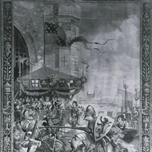
Map illustrating the Battle of the Falkland Islands on 8 December 1914, (c1920). Creator: Unknown
Map illustrating the Battle of the Falkland Islands on 8 December 1914, (c1920). Diagram showing movements during the Battle of the Falkland Islands, a naval engagement of the First World War, fought in the South Atlantic between the Royal Navy and the Kaiserliche Marine (Imperial German Navy). The German SMS Scharnhorst was lost with all hands. From " The Great World War - A History" Volume II, edited by Frank A Mumby. [The Gresham Publishing Company Ltd, London, c1920]
Heritage Images features heritage image collections
Media ID 19175245
© The Print Collector/Heritage Images
1st Baronet A History Atlantic Ocean Diagram Frank Arthur Frank Arthur Mumby Gneisenau Gresham Publishing Co Ltd Gresham Publishing Company Keystone Archives Mumby Mumby Frank Arthur Naval Battle Naval Ship Ocean Royal Navy Sea Battle Squadron The Great World War The Great World War A History Theatre Of War Warships Battle Of The Falkland Islands Falkland Islands Naval Warfare South Atlantic Sturdee Warship
16"x20" (51x41cm) Metal Print
Step back in time with our exclusive Media Storehouse Metal Print featuring an intriguing map illustrating the Battle of the Falkland Islands on 8 December 1914. This captivating diagram, sourced from Heritage Images, showcases the movements during this historic naval engagement of the First World War. Bring the rich history of this pivotal moment to your home or office with our high-quality Metal Print, which showcases vibrant colors and stunning detail on a durable, lightweight metal surface. Perfect for history enthusiasts and collectors, this unique piece is an unforgettable addition to any space.
Made with durable metal and luxurious printing techniques, our metal photo prints go beyond traditional canvases, adding a cool, modern touch to your space. Wall mount on back. Eco-friendly 100% post-consumer recycled ChromaLuxe aluminum surface. The thickness of the print is 0.045". Featuring a Scratch-resistant surface and Rounded corners. Backing hangers are attached to the back of the print and float the print 1/2-inch off the wall when hung, the choice of hanger may vary depending on size and International orders will come with Float Mount hangers only. Finished with a brilliant white high gloss surface for unsurpassed detail and vibrance. Printed using Dye-Sublimation and for best care we recommend a non-ammonia glass cleaner, water, or isopropyl (rubbing) alcohol to prevent harming the print surface. We recommend using a clean, lint-free cloth to wipe off the print. The ultra-hard surface is scratch-resistant, waterproof and weatherproof. Avoid direct sunlight exposure.
Made with durable metal and luxurious printing techniques, metal prints bring images to life and add a modern touch to any space
Estimated Image Size (if not cropped) is 40.6cm x 50.8cm (16" x 20")
Estimated Product Size is 41.2cm x 51.4cm (16.2" x 20.2")
These are individually made so all sizes are approximate
Artwork printed orientated as per the preview above, with portrait (vertical) orientation to match the source image.
FEATURES IN THESE COLLECTIONS
> Arts
> Art Movements
> Related Images
> Arts
> Artists
> O
> Oceanic Oceanic
> Europe
> United Kingdom
> England
> Herefordshire
> Ledbury
> Charles II
> Europe
> United Kingdom
> England
> London
> Art
> Theatre
> Europe
> United Kingdom
> England
> London
> Royalty
> Europe
> United Kingdom
> Scotland
> Fife
> Falkland
> Historic
> Battles
> Related Images
> Historic
> World War I and II
> Naval warfare
> Historic
> World War I and II
> World War I
> Historic
> World War I and II
EDITORS COMMENTS
This print showcases a map illustrating the Battle of the Falkland Islands, a significant naval engagement during World War I. The diagram depicts the movements of both the Royal Navy and the Imperial German Navy in this fierce battle fought in the South Atlantic on 8 December 1914. The map highlights key locations such as the Falkland Islands, where this intense confrontation took place. The Battle of the Falkland Islands resulted in a decisive victory for Britain, with Admiral Sir Frederick Charles Doveton Sturdee leading his fleet to triumph over their German counterparts. This historical moment is captured within these intricate lines and markings. The image is sourced from "The Great World War - A History". Volume II, edited by Frank A Mumby and published by The Gresham Publishing Company Ltd in London around 1920. It serves as a visual representation of an important chapter in maritime warfare history. Notably, this photograph does not mention any commercial use or affiliation with any specific company but rather focuses on preserving historical significance. Through this image, viewers can gain insight into naval warfare strategies employed during one of the most tumultuous periods of human history – World War I.
MADE IN THE USA
Safe Shipping with 30 Day Money Back Guarantee
FREE PERSONALISATION*
We are proud to offer a range of customisation features including Personalised Captions, Color Filters and Picture Zoom Tools
SECURE PAYMENTS
We happily accept a wide range of payment options so you can pay for the things you need in the way that is most convenient for you
* Options may vary by product and licensing agreement. Zoomed Pictures can be adjusted in the Basket.