Metal Print > Arts > Landscape paintings > Waterfall and river artworks > River artworks
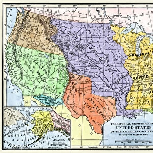
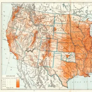
Metal Print : MAP: UNITED STATES, 1820. Engraved map of the United States, 1820, drawing on the geographical discoveries of the Lewis


![]()
Metal Prints from Granger
MAP: UNITED STATES, 1820. Engraved map of the United States, 1820, drawing on the geographical discoveries of the Lewis
MAP: UNITED STATES, 1820. Engraved map of the United States, 1820, drawing on the geographical discoveries of the Lewis & Clark expedition
Granger holds millions of images spanning more than 25,000 years of world history, from before the Stone Age to the dawn of the Space Age
Media ID 6617689
1820 Louisiana Purchase Territory Westward Expansion
16"x24" (61x41cm) Metal Print
Step back in time with our vintage MAP: UNITED STATES, 1820 Metal Print from Media Storehouse. This beautifully detailed engraving, drawn from the extensive collection of The Granger Collection, showcases the United States as it was known in 1820, reflecting the geographical discoveries of the renowned Lewis & Clark expedition. Bring history into your home or office with this unique, high-quality metal print. The rich, vibrant colors and textures are sure to captivate and inspire. Order now and transport yourself back in time.
Made with durable metal and luxurious printing techniques, our metal photo prints go beyond traditional canvases, adding a cool, modern touch to your space. Wall mount on back. Eco-friendly 100% post-consumer recycled ChromaLuxe aluminum surface. The thickness of the print is 0.045". Featuring a Scratch-resistant surface and Rounded corners. Backing hangers are attached to the back of the print and float the print 1/2-inch off the wall when hung, the choice of hanger may vary depending on size and International orders will come with Float Mount hangers only. Finished with a brilliant white high gloss surface for unsurpassed detail and vibrance. Printed using Dye-Sublimation and for best care we recommend a non-ammonia glass cleaner, water, or isopropyl (rubbing) alcohol to prevent harming the print surface. We recommend using a clean, lint-free cloth to wipe off the print. The ultra-hard surface is scratch-resistant, waterproof and weatherproof. Avoid direct sunlight exposure.
Made with durable metal and luxurious printing techniques, metal prints bring images to life and add a modern touch to any space
Estimated Product Size is 61.5cm x 41.2cm (24.2" x 16.2")
These are individually made so all sizes are approximate
Artwork printed orientated as per the preview above, with landscape (horizontal) orientation to match the source image.
FEATURES IN THESE COLLECTIONS
> Granger Art on Demand
> Maps
> Arts
> Landscape paintings
> Waterfall and river artworks
> River artworks
> Maps and Charts
> Early Maps
> Maps and Charts
> Related Images
EDITORS COMMENTS
This print showcases an engraved map of the United States from the year 1820, meticulously drawing on the geographical discoveries made during the renowned Lewis & Clark expedition. The map beautifully captures a pivotal moment in American history, as it reflects both the late stages of westward expansion and the early development of this great nation. The intricate details depicted on this map highlight various territories and rivers that played significant roles in shaping America's destiny. It serves as a visual testament to the vastness and diversity of this young country at that time. One cannot help but be mesmerized by its artistry, which expertly combines accuracy with artistic flair. Of particular note is how this map represents one of America's most monumental acquisitions – the Louisiana Purchase. This historic event doubled the size of our nation overnight and opened up new opportunities for exploration, settlement, and trade. As we gaze upon this remarkable piece from The Granger Collection, we are transported back to a time when America was still forging its identity amidst untamed wildernesses and uncharted territories. It reminds us not only of our rich history but also inspires us to appreciate those who fearlessly ventured into unknown lands to shape our present reality. Whether you are an avid historian or simply captivated by artistry, this print is sure to ignite your imagination and spark conversations about America's past achievements while serving as a reminder that there is always more to discover within ourselves and beyond our borders.
MADE IN THE USA
Safe Shipping with 30 Day Money Back Guarantee
FREE PERSONALISATION*
We are proud to offer a range of customisation features including Personalised Captions, Color Filters and Picture Zoom Tools
SECURE PAYMENTS
We happily accept a wide range of payment options so you can pay for the things you need in the way that is most convenient for you
* Options may vary by product and licensing agreement. Zoomed Pictures can be adjusted in the Cart.