Home > North America > United States of America > New York > New York > Queens > Forest Park
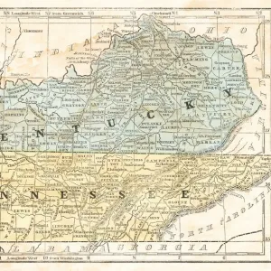
Plate 32: Bounded by Forest Park Magnolia Avenue, Union Place, Tulip Street, Cleveland

![]()
Wall Art and Photo Gifts from Liszt Collection
Plate 32: Bounded by Forest Park Magnolia Avenue, Union Place, Tulip Street, Cleveland
Plate 32: Bounded by Forest Park Magnolia Avenue, Union Place, Tulip Street, Cleveland Avenue, Washington Avenue, Myrtle Avenue, Division Avenue, ... Maple Grove Cemetery, Newtown Road, Van Wyck Avenue, Atlantic Avenue and Union Place
Liszt Collection of nineteenth-century engravings and images to browse and enjoy
Media ID 12671865
© Quint Lox Limited
Bounded By Cartographic Historic Map Myrtle Avenue Plate 32 Vintage Map Cleveland Avenue Newtown Road Old Map Union Place Washington Avenue
FEATURES IN THESE COLLECTIONS
> Europe
> United Kingdom
> England
> Cleveland
> Europe
> United Kingdom
> Wales
> Powys
> Newtown
> North America
> United States of America
> Maps
> North America
> United States of America
> New York
> New York
> Maps
> North America
> United States of America
> New York
> New York
> Queens
> Forest Park
> North America
> United States of America
> Washington
> Related Images
EDITORS COMMENTS
This vintage map, titled "Plate 32: Bounded by Forest Park Magnolia Avenue, Union Place, Tulip Street, Cleveland" takes us on a journey through the historic streets of New York. The intricate cartographic details transport us back in time to an era when these roads were bustling with activity and life. As we explore the map's boundaries, we encounter notable landmarks such as Washington Avenue and Maple Grove Cemetery. These places hold stories of their own, whispering tales from the past that have shaped this vibrant city. The artist behind this print has masterfully captured the essence of old-world charm through delicate strokes and faded hues. Each street is meticulously drawn, inviting our imagination to wander along its paths and envision what life was like during those times. This piece from the Liszt Collection serves as a captivating window into history—a testament to the artistry of cartography and its ability to preserve memories for generations to come. It reminds us that beneath our modern metropolis lies a rich tapestry woven with countless narratives waiting to be discovered. Whether you're an avid collector or simply appreciate the beauty of vintage maps, this print will undoubtedly add character and intrigue to any space it graces. Let it transport you back in time as you marvel at the intricacies of New York's past.
MADE IN THE USA
Safe Shipping with 30 Day Money Back Guarantee
FREE PERSONALISATION*
We are proud to offer a range of customisation features including Personalised Captions, Color Filters and Picture Zoom Tools
SECURE PAYMENTS
We happily accept a wide range of payment options so you can pay for the things you need in the way that is most convenient for you
* Options may vary by product and licensing agreement. Zoomed Pictures can be adjusted in the Cart.